St. Peter am Kammersberg | |
|---|---|
 St. Peter am Kammersberg Location within Austria | |
| Coordinates: 47°11′00″N 14°11′00″E / 47.18333°N 14.18333°E | |
| Country | Austria |
| State | Styria |
| District | Murau |
| Government | |
| • Mayor | Herbert Gögelburger (ÖVP) |
| Area | |
| • Total | 84.6 km2 (32.7 sq mi) |
| Elevation | 850 m (2,790 ft) |
| Population (2018-01-01)[2] | |
| • Total | 2,043 |
| • Density | 24/km2 (63/sq mi) |
| Time zone | UTC+1 (CET) |
| • Summer (DST) | UTC+2 (CEST) |
| Postal code | 8843 |
| Area code | 03536 |
| Vehicle registration | MU |
| Website | www |
Sankt Peter am Kammersberg is a small village in Austria in the state of Styria with 2,076 inhabitants (as of 2016-01-01). It was first mentioned in documents in the year 1007.
The municipality is divided as follow:
- Althofen
- Feistritz
- Kammersberg
- Mitterdorf
- Peterdorf
- Pöllau am Greim
- St. Peter
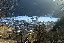
View of Sankt Peter from the top of the mountain
References
- ↑ "Dauersiedlungsraum der Gemeinden Politischen Bezirke und Bundesländer - Gebietsstand 1.1.2018". Statistics Austria. Retrieved 10 March 2019.
- ↑ "Einwohnerzahl 1.1.2018 nach Gemeinden mit Status, Gebietsstand 1.1.2018". Statistics Austria. Retrieved 9 March 2019.
External links
This article is issued from Wikipedia. The text is licensed under Creative Commons - Attribution - Sharealike. Additional terms may apply for the media files.