Santa Adélia | |
|---|---|
Municipality | |
| The Municipality of Santa Adélia | |
 Flag  Seal | |
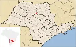 Location of Santa Adélia | |
 Santa Adélia | |
| Coordinates: 21°14′34″S 48°48′14″W / 21.24278°S 48.80389°W | |
| Country | |
| Region | Southeast |
| State | |
| Government | |
| • Mayor | Guilherme Colombo (DEM) |
| Area | |
| • Total | 330.9 km2 (127.8 sq mi) |
| Elevation | 618 m (2,028 ft) |
| Population (2020 [1]) | |
| • Total | 15,561 |
| • Density | 43.32/km2 (112.2/sq mi) |
| Time zone | UTC−3 (BRT) |
| Postal Code | 15950-000 |
| Area code | +55 17 |
| Website | Prefecture of Santa Adélia |
Santa Adélia is a municipality in the state of São Paulo, Brazil. The city has a population of 15,561 inhabitants and an area of 330.9 km².[2] Santa Adélia belongs to the Mesoregion of São José do Rio Preto.
Economy
The Tertiary sector corresponds to 69.91% of Santa Adélia's GDP. The Primary sector is 19.73% of the GDP and the Industry corresponds to 10.36%.[3]
References
- ↑ IBGE 2020
- ↑ "2010 Census of the IBGE - Population - Table 2.1.20" (PDF) (in Portuguese). IBGE.gov.br. Retrieved 28 July 2011.
- ↑ "Municipal Profile at SEADE - Search". SEADE.gov.br. Archived from the original on 23 August 2011. Retrieved 28 July 2011.
This article is issued from Wikipedia. The text is licensed under Creative Commons - Attribution - Sharealike. Additional terms may apply for the media files.