Sauveterre-de-Rouergue | |
|---|---|
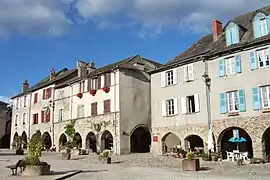 The main square in Sauveterre-de-Rouergue | |
.svg.png.webp) Coat of arms | |
Location of Sauveterre-de-Rouergue | |
 Sauveterre-de-Rouergue  Sauveterre-de-Rouergue | |
| Coordinates: 44°13′18″N 2°19′07″E / 44.2217°N 2.3186°E | |
| Country | France |
| Region | Occitania |
| Department | Aveyron |
| Arrondissement | Villefranche-de-Rouergue |
| Canton | Ceor-Ségala |
| Government | |
| • Mayor (2020–2026) | René Mouysset[1] |
| Area 1 | 23.43 km2 (9.05 sq mi) |
| Population | 716 |
| • Density | 31/km2 (79/sq mi) |
| Time zone | UTC+01:00 (CET) |
| • Summer (DST) | UTC+02:00 (CEST) |
| INSEE/Postal code | 12262 /12800 |
| Elevation | 333–682 m (1,093–2,238 ft) (avg. 466 m or 1,529 ft) |
| 1 French Land Register data, which excludes lakes, ponds, glaciers > 1 km2 (0.386 sq mi or 247 acres) and river estuaries. | |
Sauveterre-de-Rouergue (French pronunciation: [sovtɛʁ də ʁwɛʁɡ], literally Sauveterre of Rouergue; Occitan: Sauvatèrra) is a commune in the Aveyron department in southern France. It is one of the Les Plus Beaux Villages de France (most beautiful villages of France).
Population
| Year | Pop. | ±% p.a. |
|---|---|---|
| 1968 | 964 | — |
| 1975 | 891 | −1.12% |
| 1982 | 793 | −1.65% |
| 1990 | 888 | +1.42% |
| 1999 | 832 | −0.72% |
| 2009 | 803 | −0.35% |
| 2014 | 797 | −0.15% |
| 2020 | 713 | −1.84% |
| Source: INSEE[3] | ||
See also
References
- ↑ "Répertoire national des élus: les maires" (in French). data.gouv.fr, Plateforme ouverte des données publiques françaises. 13 September 2022.
- ↑ "Populations légales 2021". The National Institute of Statistics and Economic Studies. 28 December 2023.
- ↑ Population en historique depuis 1968, INSEE
External links
Wikimedia Commons has media related to Sauveterre-de-Rouergue.
- Sauveterre-de-Rouergue (in English)
This article is issued from Wikipedia. The text is licensed under Creative Commons - Attribution - Sharealike. Additional terms may apply for the media files.