Sixty Six, South Carolina | |
|---|---|
 Sixty Six, South Carolina  Sixty Six, South Carolina | |
| Coordinates: 33°18′21″N 80°49′34″W / 33.30583°N 80.82611°W | |
| Country | United States |
| State | South Carolina |
| County | Orangeburg |
| Elevation | 141 ft (43 m) |
| Time zone | UTC-5 (Eastern (EST)) |
| • Summer (DST) | UTC-4 (EDT) |
| Area code(s) | 803, 839 |
| GNIS feature ID | 1250918[1] |
Sixty Six is an unincorporated community in Orangeburg County, South Carolina, United States. Sixty Six is located along U.S. Route 21, north of Branchville.
References
- ↑ "US Board on Geographic Names". United States Geological Survey. October 25, 2007. Retrieved January 31, 2008.
Municipalities and communities of Orangeburg County, South Carolina, United States | ||
|---|---|---|
| City | 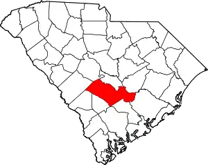 Map of South Carolina highlighting Orangeburg County | |
| Towns | ||
| CDPs | ||
| Unincorporated communities | ||
This article is issued from Wikipedia. The text is licensed under Creative Commons - Attribution - Sharealike. Additional terms may apply for the media files.