Slabtown, Pennsylvania | |
|---|---|
Unincorporated community | |
 Slabtown | |
| Coordinates: 40°52′39″N 79°23′39″W / 40.87750°N 79.39417°W | |
| Country | United States |
| State | Pennsylvania |
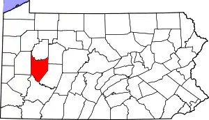
| County | Armstrong |
| Township | Boggs |
| Elevation | 1,096 ft (334 m) |
| Time zone | UTC-5 (Eastern (EST)) |
| • Summer (DST) | UTC-4 (EDT) |
| GNIS feature ID | 1187776[1] |
Slabtown is an unincorporated community in Boggs Township, Armstrong County, Pennsylvania, United States.[1] It has also been known as Baum. The community is 9.1 miles (14.6 km) north of Kittanning along Pennsylvania Route 28-Pennsylvania Route 66.
References
This article is issued from Wikipedia. The text is licensed under Creative Commons - Attribution - Sharealike. Additional terms may apply for the media files.