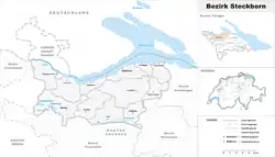
Steckborn District
Bezirk Steckborn | |
|---|---|
District | |
 | |
| Country | |
| Canton | |
| Capital | Steckborn |
| Area | |
| • Total | 132.9 km2 (51.3 sq mi) |
| Population (2009) | |
| • Total | 18,215 |
| • Density | 140/km2 (350/sq mi) |
| Time zone | UTC+1 (CET) |
| • Summer (DST) | UTC+2 (CEST) |
| Municipalities | 15 |
Steckborn District is a former district of the canton of Thurgau, Switzerland. It had a population of 18,215 (as of 2009).[1] Its capital was the town of Steckborn.
The former district contained the following municipalities:
| Coat of arms | Municipality | Population (31 December 2020)[1] |
Area km²[2] |
|---|---|---|---|
| Berlingen | 906 | 4.0 | |
| Eschenz | 1,868 | 12.0 | |
| Herdern | 1,117 | 13.7 | |
| Homburg | 1,543 | 24.1 | |
| Hüttwilen | 1,765 | 17.6 | |
| Mammern | 677 | 5.5 | |
| Müllheim | 3,002 | 8.7 | |
| Pfyn | 2,103 | 13.0 | |
| Raperswilen | 416 | 7.7 | |
| Salenstein | 1,411 | 6.6 | |
| Steckborn | 3,840 | 8.8 | |
| Wagenhausen | 1,770 | 11.2 |
References
- 1 2 "Ständige und nichtständige Wohnbevölkerung nach institutionellen Gliederungen, Geburtsort und Staatsangehörigkeit". bfs.admin.ch (in German). Swiss Federal Statistical Office - STAT-TAB. 31 December 2020. Retrieved 21 September 2021.
- ↑ Swiss Federal Statistical Office-Land Use Statistics 2009 data (in German) accessed 25 March 2010
This article is issued from Wikipedia. The text is licensed under Creative Commons - Attribution - Sharealike. Additional terms may apply for the media files.