Stoltebüll Stoltebøl | |
|---|---|
 Coat of arms | |
Location of Stoltebüll Stoltebøl within Schleswig-Flensburg district 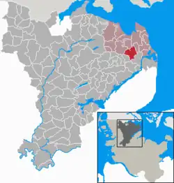 | |
 Stoltebüll Stoltebøl  Stoltebüll Stoltebøl | |
| Coordinates: 54°41′45″N 9°52′35″E / 54.69583°N 9.87639°E | |
| Country | Germany |
| State | Schleswig-Holstein |
| District | Schleswig-Flensburg |
| Municipal assoc. | Geltinger Bucht |
| Government | |
| • Mayor | Hans-Jürgen Schwager |
| Area | |
| • Total | 16.40 km2 (6.33 sq mi) |
| Elevation | 28 m (92 ft) |
| Population (2022-12-31)[1] | |
| • Total | 667 |
| • Density | 41/km2 (110/sq mi) |
| Time zone | UTC+01:00 (CET) |
| • Summer (DST) | UTC+02:00 (CEST) |
| Postal codes | 24409 |
| Dialling codes | 04643 |
| Vehicle registration | SL |
Stoltebüll (Danish: Stoltebøl) is a municipality in the district of Schleswig-Flensburg, in Schleswig-Holstein, Germany.
The municipality comprises six small villages: Stoltebüll, Gulde, Schrepperie, Schörderup, Vogelsang and Wittkiel. Stoltebüll is located in the east of Anglia, about seven kilometers from the Baltic Sea, in a varied hilly landscape with heights of up to 57 m above sea level. The landscape is characterized by hedgerows, fields, meadows and small forests.
The neoclassical Drült manor house, situated in extensive woodland, was rebuilt in an landscape garden after a fire caused by lightning around 1800. It contains a large library that has been collected over the centuries.

Drült Manor House
References
This article is issued from Wikipedia. The text is licensed under Creative Commons - Attribution - Sharealike. Additional terms may apply for the media files.