Sugarloaf Shores, Florida | |
|---|---|
 Sugarloaf Lodge on U.S. 1 in Sugarloaf Shores | |
 Sugarloaf Shores  Sugarloaf Shores | |
| Coordinates: 24°38′38″N 81°33′43″W / 24.644°N 81.562°W | |
| Country | |
| State | |
| County | Monroe |
| Elevation | 3 ft (1 m) |
| Time zone | UTC-5 (Eastern (EST)) |
| • Summer (DST) | UTC-4 (EDT) |
Sugarloaf Shores is an unincorporated community in Monroe County, Florida, United States, located in the lower Florida Keys on Lower Sugarloaf Key near mile marker 17 on US 1 (the Overseas Highway).
It is directly across US 1 from the ghost town of Perky.
Geography
It is located at 24°38′38″N 81°33′43″W / 24.644°N 81.562°W with an elevation of 3 feet (1 m).[1]

Road to Sugarloaf Airport
References
External links
24°38′38″N 81°33′43″W / 24.644°N 81.562°W
Municipalities and communities of Monroe County, Florida, United States | ||
|---|---|---|
| Cities | 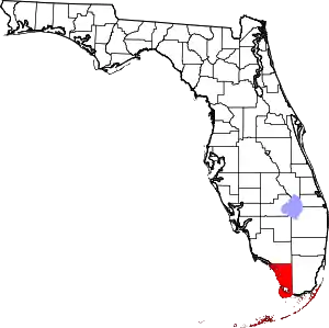 | |
| Village | ||
| CDPs | ||
| Unincorporated communities | ||
| Ghost towns | ||
This article is issued from Wikipedia. The text is licensed under Creative Commons - Attribution - Sharealike. Additional terms may apply for the media files.