| Tarfessock | |
|---|---|
 | |
| Highest point | |
| Elevation | 694.2 m (2,278 ft)[1] |
| Prominence | 68.5 m (225 ft)[2] |
| Listing | Tu,Sim,D,GT,DN[3] |
| Geography | |
| Location | South Ayrshire, Scotland |
| Parent range | Range of the Awful Hand, Galloway Hills, Southern Uplands |
| OS grid | NX 40906 89186 |
| Topo map | OS Landranger 77 |
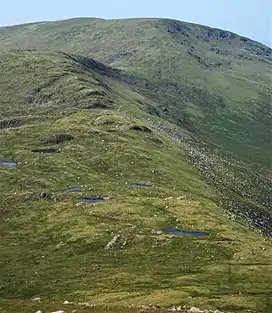
Tarfessock is a hill in the Range of the Awful Hand, a sub-range of the Galloway Hills range, part of the Southern Uplands of Scotland. A craggy hill, it is the lowest Donald in the range, being completely obscured by Kirriereoch Hill when viewed from the Merrick. A nearby south top is dotted with a series of lochans. A farmhouse of the same name is located to the west,[4] which along with the hill was at one time the property of the Marquess of Ailsa.[5]
Subsidiary SMC Summits
| Summit | Height (m) | Listing[6] |
|---|---|---|
| Tarfessock South Top | 620 | DT,sSim[7] |
References
- ↑ "Tarfessock, South Ayrshire (DG8 6TA)". OS GetOutside. Retrieved 11 April 2020.
- ↑ "Mountain Search".
- ↑ "Mountain Search".
- ↑ Ayrshire, Sheet LXIII (includes: Barr; Minnigaff) (Map). Ordnance Survey. 1858.
- ↑ Ayrshire Ordnance Survey Name Book. Vol. 9. Ordnance Survey. pp. 51, 55. OS1/3/9/51 – via ScotlandsPlaces.
- ↑ "Database of British and Irish Hills: User guide".
- ↑ "Tarfessock South Top".
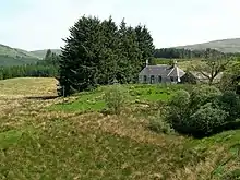
Tarfessock farm house
This article is issued from Wikipedia. The text is licensed under Creative Commons - Attribution - Sharealike. Additional terms may apply for the media files.