Tejutla, Chalatenango | |
|---|---|
Municipality | |
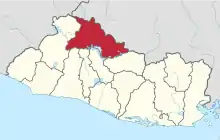
 Tejutla, Chalatenango Location in El Salvador | |
| Coordinates: 14°10′N 89°6′W / 14.167°N 89.100°W | |
| Country | |
| Departament | Chalatenango Department |
| Elevation | 1,243 ft (379 m) |
| Population (2007)VI National Census of Population and Housing | |
| • Municipality | 13,608 |
| • Urban | 5,429 |
| Time zone | UTC-6 (CST) |
| • Summer (DST) | UTC-5 (-EST) |
Tejutla is a municipality in the Chalatenango department of El Salvador.
Source: Sixth National Census of Population and Housing (http://www.censos.gob.sv/util/datos/Resultados%20VI%20Censo%20de%20Poblaci%F3n%20V%20de%20Vivienda%202007.pdf%5B%5D).
This article is issued from Wikipedia. The text is licensed under Creative Commons - Attribution - Sharealike. Additional terms may apply for the media files.