| Terras Salgadas | |
|---|---|
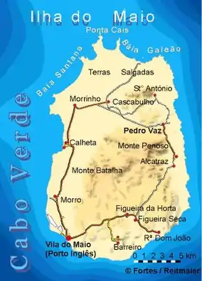 Terras Salgadas in the north of the island Maio | |
| Location | northernmost part of Maio |
Terras Salgadas (Portuguese meaning "salty lands") is a vast natural area covering the northwestern part of the island of Maio, Cape Verde. It is part of the protected area Parque Natural do Norte da Ilha do Maio.[1] It is the largest saline ecosystem of the whole archipelago, characterized by imposing sand dunes.[1] The area is rich in endemic species of sea birds, fish and sea turtles.[2][3] The nearest settlements are Morrinho, Cascabulho and Santo António. As "saline" (French) and "zoutpan" (Dutch) it was mentioned in the 1747 map by Jacques-Nicolas Bellin.[4]
See also
References
- 1 2 Áreas protegidas Maio, Maio Biodiversity Foundation
- ↑ FFEM
- ↑ Reservas Naturais, Áreas protegidas Cabo Verde
- ↑ Jacques-Nicolas Bellin (1747). "Carte des Isles du Cap Verd = Kaart van de Eilanden van Kabo Verde" (in French).
The island of Maio | ||
|---|---|---|
| Communities and settlements |  | |
| Mountains | ||
| Other geographical features | ||
This article is issued from Wikipedia. The text is licensed under Creative Commons - Attribution - Sharealike. Additional terms may apply for the media files.