Unityville, South Dakota | |
|---|---|
 Unityville, South Dakota | |
| Coordinates: 43°48′05″N 97°27′09″W / 43.80139°N 97.45250°W | |
| Country | United States |
| State | South Dakota |
| County | McCook |
| Elevation | 1,529 ft (466 m) |
| Time zone | UTC-6 (Central (CST)) |
| • Summer (DST) | UTC-5 (CDT) |
| Area code | 605 |
| GNIS feature ID | 1258713[1] |
Unityville is an unincorporated community in McCook County, South Dakota, United States. Unityville is 6.2 miles (10.0 km) north-northwest of Salem.
Unityville was originally called Stark, and under the latter name was laid out in 1907 by J. F. Stark, and named for him.[2]
References
- ↑ "Unityville". Geographic Names Information System. United States Geological Survey, United States Department of the Interior.
- ↑ Federal Writers' Project (1940). South Dakota place-names, v.1-3. University of South Dakota. p. 63.
Municipalities and communities of McCook County, South Dakota, United States | ||
|---|---|---|
| Cities | 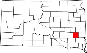 | |
| CDPs | ||
| Unincorporated community | ||
This article is issued from Wikipedia. The text is licensed under Creative Commons - Attribution - Sharealike. Additional terms may apply for the media files.