Víctor Fajardo | |
|---|---|
 The church of Sarhua | |
 Flag  Coat of arms | |
 Location of Víctor Fajardo in the Ayacucho Region | |
| Country | Peru |
| Region | Ayacucho |
| Founded | November 14, 1910 |
| Capital | Huancapi |
| Government | |
| • Mayor | Onofrio Huamaní Garcia |
| Area | |
| • Total | 2,260.19 km2 (872.66 sq mi) |
| Population | |
| • Total | 27,919 |
| • Density | 12/km2 (32/sq mi) |
| Website | www |
Víctor Fajardo Province is a province in the centre of the Ayacucho Region in Peru.
Boundaries
- North: Cangallo Province
- East: Vilcas Huamán Province and Sucre Province
- South: Lucanas Province and Huanca Sancos Province
- West: Huancavelica Region
Geography
One of the highest mountains of the district is Hatun Urqu at approximately 4,600 m (15,100 ft). Other mountains are listed below:[1]
- Allpa K'ark'a
- Ankap Wachanan
- Anta Q'asa
- Aqu Kunka
- Aqu Q'asa
- Chillwa
- Chunta
- Hamp'atuyuq
- Hatun Pampa
- Hatun Qaqa
- Huch'uy Pirwalla
- Illayuq
- Inti Watana
- Kuntur Qhata
- Kunturillu
- K'ark'a Pata
- Llallawi
- Llut'u Pukyu
- Millka
- Muyu Muyu
- Paqariq Qaqa
- Pata Kancha
- Puka Mach'ay
- Puma Ranra
- Punta Urqu
- Puywanniyuq
- Phiruru
- Qarwa Pata
- Qichqa Urqu
- Qucha Pata
- Qucha Qucha
- Qucha Urqu
- Quchayuq Urqu
- Qhata Pukyu
- Sayaq Mach'ay
- Saywa
- Sinqa
- Tawlli Urqu
- Tullpa Rumi
- Wanaku
- Wank'a Saywa
- Wanqani
- Waqra Chuku
- Yana Pukyu
- Yanaqucha
- Yuraq Urqu
Political division
The province is divided into twelve districts (Spanish: distritos, singular: distrito), each of which is headed by a mayor (alcalde). The districts, with their capitals in parentheses, are:
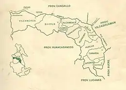
Districts in Fajardo Province
- Huancapi (Huancapi), Anexos:Ccocha y Pitahua
- Alcamenca, Anexos: Huambo, Carampa, Mirata, Unya, Eccallo, Patallacta e Irimpay
- Apongo, Anexos: Paire, Chillanccay y Huayccohuasi
- Asquipata, Anexos: Chihuire y Morcolla Chico
- Canaria, Anexos: Raccaya, Taca y Umasi
- Cayara, Anexos: Chincheros y Mayopampa
- Colca, Anexos: Quilla y San José de Sucre
- Huamanquiquia, Anexos: Patará, Tinca y Ucho
- Huancaraylla, Anexos: Circamarca y Llusita
- Huaya, Anexo: Tiquihua
- Sarhua (Sarhua), Anexos: Auquilla, Chuquihuarcaya y Tomanga
- Vilcanchos, Anexos: Cocas, Espite y Urancancha
Ethnic groups
The people in the province are mainly indigenous citizens of Quechua descent. Quechua is the language which the majority of the population (86.22%) learnt to speak in childhood, 13.42% of the residents started speaking using the Spanish language (2007 Peru Census).[2]
See also
Sources
- ↑ escale.minedu.gob.pe - UGEL map of the Víctor Fajardo Province (Ayacucho Region)
- ↑ inei.gob.pe Archived 2013-01-27 at the Wayback Machine INEI, Peru, Censos Nacionales 2007
External links
| |
|---|---|
13°41′S 74°04′W / 13.683°S 74.067°W
This article is issued from Wikipedia. The text is licensed under Creative Commons - Attribution - Sharealike. Additional terms may apply for the media files.