Wyględów | |
|---|---|
Neighbourhood of Warsaw | |
 | |
| Coordinates: 52.196718°N 20.993063°E | |
| Country | |
| Voievodship | |
| City | |
| District | Mokotów |
| Vehicle registration | WE |
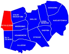
Wyględów in the greater Mokotów district
Wyględów [vɨglɛnduf] is a neighbourhood in the north-western part of the district of Mokotów in Warsaw, Poland.
The name of the area comes from the village of Wyględów-Kościesze, which was founded in the 15th century and was placed near what is now the Bełska street.
The intensive development of this area began with the construction of a fort by the Russian authorities in the second half of the 19th century. Fort Mokotów belonged to the inner ring of the forts of Warsaw.
A new stage in the development of the Fort Mokotowski area, as well as other Warsaw suburbs, came in the years 1916-1917 with new proposals on joining suburban districts to the city and establishing its new borders.[1]
Notable places
- Fort M („Mokotów”)
- Central Clinical Hospital MSWiA
- National Institute of Geriatrics, Rheumatology and Rehabilitation
- Mokotów Field
- Soviet Military Cemetery
References
External links
 Media related to Wyględów (Warsaw) at Wikimedia Commons
| City Information System areas |
|  | ||||
|---|---|---|---|---|---|---|
| National Registry of Geographical Names areas |
| |||||
| Municipal neighbourhoods | ||||||
| Others |
| |||||
This article is issued from Wikipedia. The text is licensed under Creative Commons - Attribution - Sharealike. Additional terms may apply for the media files.