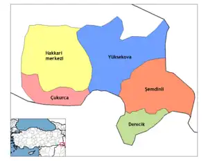
Çukurca District | |
|---|---|
 Map showing Çukurca District in Hakkâri Province | |
| Country | Turkey |
| Province | Hakkâri |
| Seat | Çukurca |
| Government | |
| • Kaymakam | Hasan Kurt |
| Area | 725 km2 (280 sq mi) |
| Population (2022)[1] | 14,333 |
| • Density | 20/km2 (51/sq mi) |
| Time zone | TRT (UTC+3) |
| Website | www |
Çukurca District is a district in the Hakkâri Province of Turkey.[2] The district had a population of 14,333 in 2022 with the town of Çukurca as its seat.[1][2] Its area is 725 km2.[3] The current district governor (kaymakam) is Hasan Kurt.[4]
The district has more unpopulated settlements than populated ones.[5]
The district was established in 1953.[6]
Settlements
There is one municipality in Çukurca District:[2]
The district has sixteen villages of which eight are unpopulated:[2][5]
Population
Population history from 2007 to 2022:[1]
| Year | Pop. | ±% p.a. |
|---|---|---|
| 2007 | 12,352 | — |
| 2012 | 15,294 | +4.37% |
| 2017 | 16,661 | +1.73% |
| 2022 | 14,333 | −2.97% |
References
- 1 2 3 "Address Based Population Registration System Results". Türkiye İstatistik Kurumu (in Turkish). Retrieved 15 February 2023.
- 1 2 3 4 5 "Türkiye Mülki İdare Bölümleri Envanteri". T.C. İçişleri Bakanlığı (in Turkish). Retrieved 19 December 2022.
- ↑ "İl ve İlçe Yüz ölçümleri". General Directorate of Mapping. Retrieved 1 March 2023.
- ↑ "Kaymakam". Çukurca District Governorate. Retrieved 30 March 2023.
- 1 2 "Çukurca köylerinin Kürtçe, Türkçe ve eski isimleri" (in Turkish). Retrieved 17 December 2022.
- ↑ "İl İdaresi ve Mülki Bölümler Şube Müdürlüğü İstatistikleri - İl ve İlçe Kuruluş Tarihleri" (PDF) (in Turkish). p. 38. Retrieved 27 December 2022.
This article is issued from Wikipedia. The text is licensed under Creative Commons - Attribution - Sharealike. Additional terms may apply for the media files.