Čenkovice | |
|---|---|
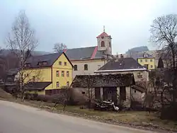
 Church of Saint Lawrence | |
 Flag  Coat of arms | |
 Čenkovice Location in the Czech Republic | |
| Coordinates: 50°0′41″N 16°40′57″E / 50.01139°N 16.68250°E | |
| Country | |
| Region | Pardubice |
| District | Ústí nad Orlicí |
| First mentioned | 1304 |
| Area | |
| • Total | 5.98 km2 (2.31 sq mi) |
| Elevation | 665 m (2,182 ft) |
| Population (2023-01-01)[1] | |
| • Total | 195 |
| • Density | 33/km2 (84/sq mi) |
| Time zone | UTC+1 (CET) |
| • Summer (DST) | UTC+2 (CEST) |
| Postal code | 561 64 |
| Website | www |
Čenkovice is a municipality and village in Ústí nad Orlicí District in the Pardubice Region of the Czech Republic. It has about 200 inhabitants. It is a centre of winter sports.
Geography
Čenkovice is located about 21 kilometres (13 mi) east of Ústí nad Orlicí and 64 km (40 mi) east of Pardubice. It lies in the Orlické Mountains. The highest point is the mountain Buková hora at 958 m (3,143 ft) above sea level. The Bystřec stream originates in the village and flows through the municipality.
History
The first written mention of Čenkovice is from 1304.[2]
Sport
Čenkovice is known for a ski resort located on Buková hora and its surroundings. There are 65 km of cross-country trails and five ski slopes.[3]
Sights
The main landmark of Čenkovice is the Church of Saint Lawrence. It was built in the Neoclassical style in 1780–1782. It is a valuable rural church.[4]
References
- ↑ "Population of Municipalities – 1 January 2023". Czech Statistical Office. 2023-05-23.
- ↑ "Obec Čenkovice" (in Czech). Obec Čenkovice. Retrieved 2022-06-24.
- ↑ "O Skiareálu Čenkovice" (in Czech). Ski areál Čenkovice. Retrieved 2022-06-24.
- ↑ "Kostel sv. Vavřince" (in Czech). National Heritage Institute. Retrieved 2023-06-28.