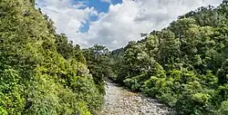
| Ōhikaiti River | |
|---|---|
 | |
| Location | |
| Country | New Zealand |
| Physical characteristics | |
| Source | |
| • location | Mount Galileo Paparoa Range |
| • elevation | 1,256 metres (4,121 ft) |
| Mouth | |
• location | Buller River |
• elevation | 20 metres (66 ft) |
| Length | 12 kilometres (7.5 mi) |
The Ōhikaiti River is a river of the West Coast Region of New Zealand's South Island. It flows north from Mount Galileo, in the Paparoa Range, paralleling the course of the larger Ōhikanui River which lies two kilometres to the west. The Ōhikaiti empties into the Buller River at the Buller Gorge, 15 kilometres southwest of Westport.[1]
The New Zealand Ministry for Culture and Heritage gives a translation of "place of small incantations" for Ōhikaiti.[2]
Ōhikaiti River has been the official name of the river since it was gazetted on 21 June 2019. The explanation is given that 'o' means place of, 'hika' is a ritual and 'iti' and 'nui' are small and large. The ritual was for a chief, Te Pūoho-o-te-rangi, who died during a raid.[3]
The river generally follows the Ōhikaiti Fault, which probably formed about 35 million years ago.[4]
A totara bridge over the Little Ohika was built in 1877,[5] but damaged by a flood on 4 November 1877.[6] It was replaced in 1889 by a bridge over the Ohika-iti, with four spans of 30 ft (9.1 m) and one of 20 ft (6.1 m).[7] The 1938 concrete bridge has two spans of 45 ft (14 m) and two of 30 ft (9.1 m).[8] SH6 now crosses the river near its mouth.[9]
See also
References
- ↑ "Place name detail: Ohikaiti River". New Zealand Gazetteer. New Zealand Geographic Board. Retrieved 23 April 2010.
- ↑ "1000 Māori place names". New Zealand Ministry for Culture and Heritage. 6 August 2019.
- ↑ "Ōhikaiti River". gazetteer.linz.govt.nz. Retrieved 16 January 2023.
- ↑ Ring, Uwe; Uysal, Ibrahim Tonguc; Tong, Kui; Todd, Andrew (2 January 2021). "K-Ar fault-gouge dating in the Lower Buller gorge constrains the formation of the Paparoa Trough, West Coast, New Zealand". New Zealand Journal of Geology and Geophysics. 64 (1): 49–61. doi:10.1080/00288306.2020.1808025. ISSN 0028-8306.
- ↑ "Westport Times". paperspast.natlib.govt.nz. 17 April 1877. Retrieved 26 January 2023.
- ↑ "THE WESTPORT AND REEFTON ROAD. Westport Times". paperspast.natlib.govt.nz. 13 November 1877. Retrieved 26 January 2023.
- ↑ "Inangahua Times". paperspast.natlib.govt.nz. 10 December 1888. Retrieved 26 January 2023.
- ↑ "PUBLIC WORKS IN BULLER Press". paperspast.natlib.govt.nz. 5 January 1938. Retrieved 26 January 2023.
- ↑ "State Hwy 6 Lower Buller Gorge". Google Maps. Retrieved 26 January 2023.
41°50′58″S 171°43′50″E / 41.849519°S 171.730652°E