| Ōhura River | |
|---|---|
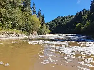 The Ōhura River at its confluence with the Whanganui River | |
 | |
| Etymology | Maori meaning "uncovered spot" |
| Native name | Ōhura (Māori) |
| Location | |
| Country | New Zealand |
| Region | Manawatū-Whanganui |
| District | Ruapehu |
| Settlements | Matiere, Tokirima |
| Physical characteristics | |
| Source | Tangitu |
| • coordinates | 38°38′38″S 175°14′28″E / 38.64389°S 175.24111°E |
| • elevation | 680 m (2,230 ft) |
| Mouth | Whanganui River |
• coordinates | 39°2′20″S 175°3′52″E / 39.03889°S 175.06444°E |
• elevation | 95 m (312 ft) |
| Length | 134 km (83 mi) |
| Basin features | |
| Progression | Ōhura River → Whanganui River |
| River system | Whanganui River |
| Tributaries | |
| • left | Taumona River |
The Ōhura River is a river of the western North Island of New Zealand. It flows southward from its source close to the town of Ōhura, and flows into the Whanganui River.
In July 2020, the name of the river was officially gazetted as Ōhura River by the New Zealand Geographic Board.[1]
References
- ↑ "Notice of approved official geographic names" (PDF). New Zealand Gazette. 16 July 2020. Retrieved 18 August 2020.
This article is issued from Wikipedia. The text is licensed under Creative Commons - Attribution - Sharealike. Additional terms may apply for the media files.