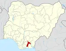
Aba South | |
|---|---|
 Aba South Location in Nigeria | |
| Coordinates: 5°06′N 7°21′E / 5.100°N 7.350°E | |
| Country | |
| State | Abia State |
| Headquarters at: | Aba |
| Government | |
| • Local Government Chairwoman | Emma Iheoma Emeruwa |
| • Local Government Deputy Chairman | Agbahiwe Omenka Callison |
| Area | |
| • Total | 89 km2 (34 sq mi) |
| Population (2006 census) | |
| • Total | 5,023,852 |
| 3-digit postal code prefix | 450 |
| ISO 3166 code | NG.AB.AS |
Aba South is a Local Government Area of Abia State, Nigeria. Its headquarters are in the city of Aba.[1]
It has an area of 49 km2 and a population of 423,852 at the 2006 census.[2]
The postal code is 450.[3]
Economy
Aba South, which is primarily a business area, is where the New Market on Ngwa Road is located.[4]
Climate/Geography
The wet season in Aba is warm and overcast while the dry season is hot and mainly cloudy, and it is very hot all year round. Over a period of the year, the temperature typically changes from 68 °F to 88 °F and is rarely below 61 °F or over 91 °F.[5][6][7]
The average temperature in Aba South LGA is 28 degrees Celsius, and there is a 72 percent humidity level in this 49 km2 area.[8]
Hot Temperature
Aba South’s climate is characterized by a hot and mainly cloudy dry season. Throughout the year, temperatures range from 68 °F to 88 °F. The warmest period occurs in February, with an average temperature of 81.6 °F, while the coldest month, July, averages around 75.4 °F.[5]
Cool Temperature
The cool season spans from June 15 to October 7, lasting for 3.8 months. During this time, daily high temperatures remain below 85°F. August stands out as the coldest month, with an average low of 70°F and a high of 82°F.[7]
Cloud
Aba South experiences varying cloud cover percentages throughout the year. The period of clearer skies starts around November 18 and lasts for approximately 2.9 months, ending by February 13. December is notably clear, with skies being clear, mostly clear, or partly cloudy 51% of the time on average. Conversely, the cloudier period spans around 9.1 months, beginning on February 13 and ending by November 18. April is the cloudiest month, with overcast or mostly cloudy skies around 85% of the time on average.[5]
Precipitation
Rainfall significantly influences Aba South’s climate throughout the year. The region’s annual mean temperature is 78.2 °F, and its climate is classified as tropical (Am) according to the Köppen-Geiger scale. Annually, Aba South receives an average precipitation of approximately 108.1 inches (2747 mm). Rainfall distribution is consistent, with September recording the highest average rainfall of 13.1 inches. Conversely, January is the driest month, with only 1.8 inches of rain. Notably, October sees the most precipitation, averaging 13.7 inches.[7]
Localities
Towns and Villages under Aba south:[2]
• Akoli
• Amanfuru
• Asaeme
• lineodi
• Ndiegoro
• Nnetu
• Oliabiain
• Umuagbai
• Uniumba
• Umuosi
• Abaukwu
• Ariaria
• Asaokpuja
• Eziukwu
• Obucla
See also
References
- ↑ "Profile of geographical entity". World Gazetteer. Retrieved 2009-11-05.
- 1 2 places (1970-01-01). "Towns & Villages in Aba South « Abia State « Nigeria". Towns & Villages. Retrieved 2023-08-21.
- ↑ "Post Offices". NIPOST. Archived from the original on 7 October 2009. Retrieved 2009-10-20.
- ↑ "Aba South Local Government Area". www.manpower.com.ng. Retrieved 2023-08-21.
- 1 2 3 "Climate and Average Weather Year Round in Aba Nigeria".
- ↑ "Aba South, Abia, Nigeria - City, Town and Village of the world". en.db-city.com. Retrieved 2023-08-05.
- 1 2 3 "Aba South weather forecast for today". justweather.org. Retrieved 2023-08-05.
- ↑ "Aba South in Abia in Nigeria - Information on Aba South - Nigeria.Places-in-the-world.com". nigeria.places-in-the-world.com. Retrieved 2023-08-21.
