Alrance | |
|---|---|
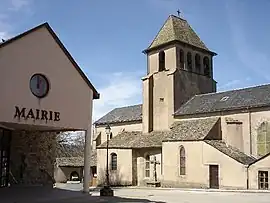 The town hall and church in Alrance | |
Location of Alrance | |
 Alrance 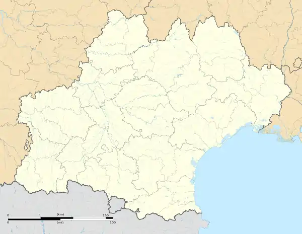 Alrance | |
| Coordinates: 44°07′57″N 2°41′03″E / 44.1325°N 2.6842°E | |
| Country | France |
| Region | Occitania |
| Department | Aveyron |
| Arrondissement | Millau |
| Canton | Raspes et Lévezou |
| Intercommunality | Lévézou Pareloup |
| Government | |
| • Mayor (2020–2026) | Bernard Cluzel[1] |
| Area 1 | 35.43 km2 (13.68 sq mi) |
| Population | 339 |
| • Density | 9.6/km2 (25/sq mi) |
| Time zone | UTC+01:00 (CET) |
| • Summer (DST) | UTC+02:00 (CEST) |
| INSEE/Postal code | 12006 /12430 |
| Elevation | 719–971 m (2,359–3,186 ft) (avg. 735 m or 2,411 ft) |
| 1 French Land Register data, which excludes lakes, ponds, glaciers > 1 km2 (0.386 sq mi or 247 acres) and river estuaries. | |
Alrance (French pronunciation: [alʁɑ̃s]; Occitan: Alrança) is a commune in the Aveyron department in the Occitanie region of southern France.
The inhabitants of the commune are known as Alrançais or Alrançaises[3]
Geography
Alrance is located some 30 km west of Millau and about 50 km north-east of Albi. The commune can be accessed by the D56 road which runs north-east from Durenque and intersects the road D25 in the commune. It continues north through the commune to Arvieu. The D25 comes south-east from Salmiech through most of the length of the commune and continues south-east to Villefranche-de-Panat. Access to the village is from the north-east on road D659 which runs off the D577 south of the Lac de Pareloup. The D659 runs south-west and ends at the village. The D528 also runs off the D25 in the south of the commune to the village.[4]
The commune is mostly farmland with some forest and covered by many country roads. There are a number of other hamlets and villages in the commune. These are:
- L'Adrech
- Bonneguide
- Boussinesq
- Le Bouviale
- La Capelle Farcel
- La Coste
- Las Fenials
- Flauvelou
- Fretanels
- Le Jouanesq
- Lacan
- Le Mas Nespoulous
- Le Mas Viala
- Le Mas Vialet
- Montcouzac
- Nazareth
- La Niade
- Pentezac
- Peyrebrune
- La Rouquette
- Le Sales
- La Vacaresse
A number of streams rise in the commune and flow to the Lac de Villefranche-de-Panat at the southern border of the commune. The streams include L'Alrance, Ruisseau du Lagasi, and several others. Some streams rise in the north of the commune and flow northwards eventually joining the river Céor which eventually flows to the Viaur at Castelpers.[4]
Neighbouring communes and villages
Places adjacent to Alrance | ||||||||||||||||
|---|---|---|---|---|---|---|---|---|---|---|---|---|---|---|---|---|
| ||||||||||||||||
Administration
List of Successive Mayors of Alrance[5]
| From | To | Name |
|---|---|---|
| 1844 | 1856 | Jean Joseph Terral |
| 1856 | 1860 | Adrien Seguret |
| 1861 | 1862 | Jean-Antoine Barthe |
| 1862 | 1864 | Jean-Joseph Terral |
| 1864 | 1870 | Jean-Antoine Barthe |
| 1870 | 1871 | François Gisquet |
| 1871 | 1878 | Joseph Gagraud |
| 1878 | 1916 | Adolphe Gagraud |
| 1916 | 1919 | Léopold Gautier |
| 1919 | 1934 | Adolphe Gagraud |
| 1934 | 1953 | Paul Serin |
| 1953 | 1959 | Gabriel Gintrand |
| 1959 | 1971 | Edouard Galtier |
| 1971 | 1977 | Auguste Fabre |
| 1977 | 2001 | Hubert Bonnefous |
| 2001 | 2008 | Jacques Montrozier |
| 2008 | 2020 | Jean-Pierre Drulhe |
| 2020 | 2026 | Bernard Cluzel |
Population
| Year | Pop. | ±% p.a. |
|---|---|---|
| 1968 | 625 | — |
| 1975 | 550 | −1.81% |
| 1982 | 528 | −0.58% |
| 1990 | 468 | −1.50% |
| 1999 | 417 | −1.27% |
| 2007 | 382 | −1.09% |
| 2012 | 383 | +0.05% |
| 2017 | 358 | −1.34% |
| Source: INSEE[6] | ||
Sites and Monuments

- The Lac de Villefranche-de-Panat just south of the commune border provides power and water activities for the commune
- The Church of Alrance and Church of La Capelle-Farcel
- The Tower of Peyrebrune (a chapel and remains of a castle)
Notable People linked to the commune
- Jean-Baptiste Angles, a missionary in Japan.
See also
References
- ↑ "Répertoire national des élus: les maires". data.gouv.fr, Plateforme ouverte des données publiques françaises (in French). 2 December 2020.
- ↑ "Populations légales 2021". The National Institute of Statistics and Economic Studies. 28 December 2023.
- ↑ Inhabitants of Aveyron (in French)
- 1 2 3 Google Maps
- ↑ List of Mayors of France (in French)
- ↑ Population en historique depuis 1968, INSEE
External links
- The tower of Peyrebrune in Alrance
- Alrance on Géoportail, National Geographic Institute (IGN) website (in French)
- Alrance on the 1750 Cassini Map