| Anykšta | |
|---|---|
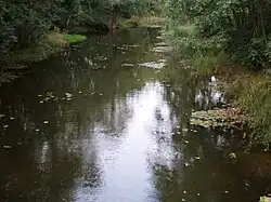
 The Anykšta nearby its source | |
| Location | |
| Country | Lithuania |
| Location | Anykščiai district municipality, Utena County |
| Physical characteristics | |
| Source | |
| • location | Rubikiai Lake |
| Mouth | |
• coordinates | 55°31′52″N 25°06′47″E / 55.5312°N 25.1131°E |
| Length | 13.8 km (8.6 mi)[1] |
| Basin size | 144.9 km2 (55.9 sq mi)[1] |
| Discharge | |
| • average | 1.18 m³/s |
| Basin features | |
| Progression | Šventoji→ Neris→ Neman→ Baltic Sea |
The Anykšta is a river of Anykščiai district municipality, Utena County, in northeastern Lithuania. It flows for 13.8 kilometres and has a basin area of 144.9 km².
The Anykšta is a left tributary of the Šventoji and joins it in the town of Anykščiai.
The name Anykšta is of unknown origin. According to one theory it could have been derived from Proto-Indoeuropean root *an-/*en- related to water.[2]
References
- 1 2 B. Gailiušis, J. Jablonskis, M Kovalenkovienė (2001). Lietuvos upės (in Lithuanian). Kaunas: Lietuvos energetikos institutas. p. 507.
{{cite book}}: CS1 maint: multiple names: authors list (link) - ↑ Vanagas, Aleksandras (1981). Lietuvių hidronimų etimologinis žodynas (in Lithuanian). Vilnius: Mokslas.
LIETUVOS RESPUBLIKOS UPIŲ IR TVENKINIŲ KLASIFIKATORIUS (Republic of Lithuania- River and Pond Classifications) Archived 2017-03-29 at the Wayback Machine. Ministry of Environment (Lithuania). Accessed 2011-11-11.
This article is issued from Wikipedia. The text is licensed under Creative Commons - Attribution - Sharealike. Additional terms may apply for the media files.