| Aowanda National Forest Recreation Area Chinese: 奧萬大國家森林遊樂區 | |
|---|---|
 | |
| Map | |
_location_map.svg.png.webp) | |
| Geography | |
| Location | Ren'ai, Nantou County, Taiwan |
| Coordinates | 23°57′14.3″N 121°10′36.4″E / 23.953972°N 121.176778°E |
| Elevation | 1,100-2,600 meters |
| Area | 2,787 hectares |
Aowanda National Forest Recreation Area (traditional Chinese: 奧萬大國家森林遊樂區; simplified Chinese: 奥万大国家森林游乐区; pinyin: Àowàndà Guójiā Sēnlín Yóulè Qū) is a forest located in Ren'ai Township, Nantou County, Taiwan.
Geology
The forest spans over an area of 2,787 hectares at an altitude of 1,100-2,600 meters.[1] It is divided into the waterfall zone, forest park, maple area and pine tree site.[2] It is located at the back of Wanda Reservoir.[3] It is home to more than 200 species of birds.[1]
Facilities
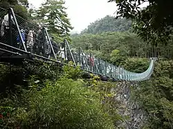
The forest features a visitor center, bird watching platform and benches.[4][5] Bridge in the forest is Aowanda Suspension Bridge.
Transportation
The forest is accessible by bus from Taichung TRA Station or Taichung HSR Station through Provincial Highway 14.[4][5][6]
See also
References
- 1 2 "Aowanda". roundTAIWANround. Retrieved 28 August 2019.
- ↑ Lin, K. "Aowanda National Forest Recreation Area". TravelKing. Retrieved 28 August 2019.
- ↑ Liao, George (4 February 2020). "Aowanda in central Taiwan rolls out discounted weekday room rates with 2 free meals". Taiwan News. Retrieved 4 February 2020.
- 1 2 "Aowanda National Forest Recreation Area". Taiwan, the Heart of Asia. Retrieved 28 August 2019.
- 1 2 "Aowanda National Forest Recreation Area". Lonely Planet. Retrieved 28 August 2019.
- ↑ "Aowanda National Forest Recreation Area". Taiwanese Secrets. Retrieved 28 August 2019.
External links
Wikimedia Commons has media related to Aowanda National Forest Recreation Area.
This article is issued from Wikipedia. The text is licensed under Creative Commons - Attribution - Sharealike. Additional terms may apply for the media files.