Apremont | |
|---|---|
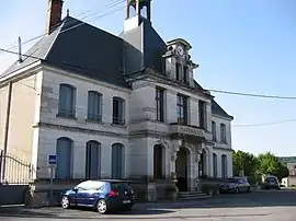
 The town hall in Apremont | |
.svg.png.webp) Coat of arms | |
Location of Apremont | |
 Apremont  Apremont | |
| Coordinates: 49°16′11″N 4°59′10″E / 49.2698°N 4.9862°E | |
| Country | France |
| Region | Grand Est |
| Department | Ardennes |
| Arrondissement | Vouziers |
| Canton | Attigny |
| Intercommunality | Argonne Ardennaise |
| Government | |
| • Mayor (2020–2026) | Bernard Deguy[1] |
| Area 1 | 12.86 km2 (4.97 sq mi) |
| Population | 119 |
| • Density | 9.3/km2 (24/sq mi) |
| Time zone | UTC+01:00 (CET) |
| • Summer (DST) | UTC+02:00 (CEST) |
| INSEE/Postal code | 08017 /08250 |
| Elevation | 137–247 m (449–810 ft) |
| 1 French Land Register data, which excludes lakes, ponds, glaciers > 1 km2 (0.386 sq mi or 247 acres) and river estuaries. | |
Apremont (French pronunciation: [apʁəmɔ̃]) is a commune in the department of Ardennes in the Grand Est region of northern France.
Geography
Apremont is located some 40 km north-west of Verdun, 6 km north-west of Varennes-en-Argonne, and 5 km south-east of Fléville. The south-western border of the commune is the border between the departments of Ardennes and Marne while the south-eastern border is the border between Ardennes and Meuse departments. Access to the commune is by the D946 road from Fléville in the north-west passing through the eastern part of the commune and continuing to Varennes-en-Argonne. Access to the village is by the D242 running off the D946. There are also the D42 road from Chatel-Chéhéry to the north to the village and the D442 from the village west to the commune border where it becomes the D66 and continues to join the D63. More than half of the commune is heavily forested in the west while the smaller eastern portion is farmland.[3]
The Aire river flows through the commune from west to east near the village and forms part of the northern border of the commune. The Ruisseau de Chaudron flows from the north-east into the Aire.[3]
Neighbouring communes and villages
History
On April 18, 1918, French and American troops fought German forces near the town. Many participants were from Massachusetts and there is a park in Westfield, Massachusetts to honor those who fought in the battle.[4][5] In October 1918 this town was the site of a battle between the U.S. Army's 28th (Pennsylvania) Division and German forces.
Administration
List of Successive Mayors[6]
| From | To | Name |
|---|---|---|
| 2001 | 2008 | Christophe Rogie |
| 2008 | 2020 | Suzanne Raulin |
| 2020 | current | Bernard Deguy |
Demography
In 2017 the commune had 117 inhabitants.
|
| ||||||||||||||||||||||||||||||||||||||||||||||||||||||||||||||||||||||||||||||||||||||||||||||||||||||||||||
| Source: EHESS[7] and INSEE[8] | |||||||||||||||||||||||||||||||||||||||||||||||||||||||||||||||||||||||||||||||||||||||||||||||||||||||||||||
See also
External links
- Apremont on the old National Geographic Institute website (in French)
- Apremont on Géoportail, National Geographic Institute (IGN) website (in French)
- Apremont on the 1750 Cassini Map
References
- ↑ "Répertoire national des élus: les maires" (in French). data.gouv.fr, Plateforme ouverte des données publiques françaises. 13 September 2022.
- ↑ "Populations légales 2021". The National Institute of Statistics and Economic Studies. 28 December 2023.
- 1 2 3 Google Maps
- ↑ "Red Bluff Daily News 19 April 1918 — California Digital Newspaper Collection".
- ↑ "Archived copy". Archived from the original on 4 March 2016. Retrieved 12 April 2017.
{{cite web}}: CS1 maint: archived copy as title (link) - ↑ List of Mayors of France
- ↑ Des villages de Cassini aux communes d'aujourd'hui: Commune data sheet Apremont, EHESS (in French).
- ↑ Population en historique depuis 1968, INSEE