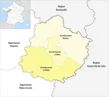
The 3 arrondissements of the Sarthe department are:[1]
- Arrondissement of La Flèche, (subprefecture: La Flèche) with 118 communes. The population of the arrondissement was 152,008 in 2016.
- Arrondissement of Mamers, (subprefecture: Mamers) with 191 communes.[2] The population of the arrondissement was 150,238 in 2016.
- Arrondissement of Le Mans, (prefecture of the Sarthe department: Le Mans) with 45 communes.[3] The population of the arrondissement was 265,315 in 2016.
History
In 1800 the arrondissements of Le Mans, La Flèche, Mamers and Saint-Calais were established. The arrondissement of Saint-Calais was disbanded in 1926.[4] In February 2006 the arrondissement of Le Mans lost the five cantons of La Chartre-sur-le-Loir, Château-du-Loir, Le Grand-Lucé, Loué and La Suze-sur-Sarthe to the arrondissement of La Flèche, and the six cantons of Bouloire, Conlie, Montfort-le-Gesnois, Saint-Calais, Sillé-le-Guillaume and Vibraye to the arrondissement of Mamers.[4][5] In August 2012 the commune Champagné passed from the arrondissement of Mamers to the arrondissement of Le Mans, and the communes Beaufay, Courcemont and Savigné-l'Évêque passed from the arrondissement of Le Mans to the arrondissement of Mamers.[6]
References
- ↑ "Populations légales 2016" (PDF). INSEE. December 2018. Retrieved 2019-10-25.
- ↑ "Arrondissement de Mamers (722)". INSEE. Retrieved 2019-10-03.
- ↑ "Arrondissement du Mans (723)". INSEE. Retrieved 2019-10-03.
- 1 2 Historique de la Sarthe
- ↑ "Arrêté préfectoral, 13 février 2006. Modification des limites territoriales des arrondissements du département de la Sarthe" (PDF). Archived from the original (PDF) on 2011-02-24. Retrieved 2019-10-25.
- ↑ "Arrêté N° 2012235-0008" (PDF). 2012-08-22. Retrieved 2019-10-03.