 Title page (copy owned by the Derby Museum and Art Gallery). | |
| Author | John Flamsteed |
|---|---|
| Illustrator | James Thornhill |
| Country | England |
| Subject | Astronomy |
Publication date | 1729 |
The Atlas Coelestis is a star atlas published posthumously in 1729, based on observations made by the First Astronomer Royal, John Flamsteed.[1]
The Atlas – the largest that ever had been published and the first comprehensive telescopic star catalogue and companion celestial atlas[2][3] – contains 26 maps of the major constellations visible from Greenwich, with drawings made in the Rococo style by James Thornhill. It also presents two planispheres designed by Abraham Sharp.[1]
History
_3993.jpg.webp)
The first stellar atlas based in telescopic observations, the Atlas Coelestis was published only ten years after the death of Flamsteed, by his widow, assisted by Joseph Crosthwait and Abraham Sharp. It was preceded by the opus "Stellarum inerrantium Catalogus Britannicus" (or simply "British Catalogue", published in 1725, with 2919 stars).[4]
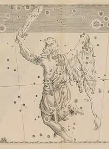
One of Flamsteed's main motivations to produce the Atlas, was to correct the representation of the figures of the constellations, as made by Bayer in his "Uranometria" (1603). Bayer represented the figures viewed from behind (not from the front, as was done since the time of Ptolemy), which reversed the placement of stars and created unnecessary confusion.[2]
 Orion, as seen in Flamsteed's Atlas Coelestis.
 Orion, as seen in Bayer's Uranometria.
The publication enjoyed immediate success, becoming the standard reference for professional astronomers for nearly a century. Even so, three objections have been raised regarding it: the high price, great size (making it difficult to handle) and low artistic quality (many criticisms were made to the drawings by James Thornhill, particularly regarding the representation of Aquarius).[4]
This led John Bevis to try to improve the Atlas. In 1745, he produced the "Uranographia Britannica", with smaller dimensions, updated with observations and more artistic pictures. However, this atlas was never officially published and at the present, there are only 16 known copies.[5]
The Atlas Fortin-Flamsteed
Finally, the changes in the positions of stars (the original observations were made in the 1690s), led to an update made in 1776 by the French engineer Jean Nicolas Fortin, supervised by the astronomers Le Monnier and Messier, from the Royal Academy of Sciences in Paris.[4]
The new version, called Atlas Fortin-Flamsteed, had 1/3 of the size of the original, but kept the same table structure. There is also some artistic retouching to some illustrations (mostly Andromeda, Virgo and Aquarius).[4] Fortin called this the Second Edition because he regarded Flamsteed’s original as the First Edition.[6]
The names of the constellations are in French (not in Latin) and the Atlas included some nebulae discovered after the death of Flamsteed.[4]
In 1795, a third edition was published, produced by Pierre Méchain and Jérôme Lalande, with new constellations and many more nebulae.[4] A Portuguese edition appeared in 1804, translated by the Portuguese astronomer and cartographer Francisco António Ciera (1763–1814).[6]
References
- 1 2 Davide Neri. "John Flamsteed, Atlas coelestis". Retrieved 8 May 2011.
- 1 2 Linda Hall Library (ed.). "Flamsteed, John. Atlas coelestis. London, 1729". Archived from the original on 27 September 2011. Retrieved 12 May 2011.
- ↑ Stephenson, Bruce; Bolt, Marvin; Friedman, Anna Felicity (2000). The Universe Unveiled: Instruments and Images through History. Cambridge, UK: Cambridge University Press. p. 50. ISBN 0-521-79143-X.
- 1 2 3 4 5 6 Giangi Caglieris (2002). "On-line Flamsteed - Fortin Atlas Celeste - 1776". Retrieved 8 May 2011.
- ↑ Michael Oates (17 February 2007). "Atlas Celeste". Archived from the original on 18 May 2011. Retrieved 8 May 2011.
- 1 2 Ian Ridpath (2021). "Antique Star Atlases: The 'French Flamsteed' (1776, 1795)". Retrieved 30 January 2021.
External links
- "Atlas Coelestis". RareMaps.com. - scan of the 1st edition (1729)
- "Atlas coelestis". National Library of Australia. Retrieved 8 May 2010. - full scan of the 2nd edition (1753)
- "Atlas Céleste de Flamstéed". Utrecht University. - scan of the 3rd edition (1776)
- Giangi Caglieris. "Flamsteed - Fortin Atlas Coeleste" (in English and Italian). Retrieved 8 May 2010.