Native name: 粟島 | |
|---|---|
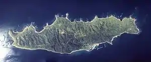
 Aerial photograph of Awashima in 1977 | |
 | |
| Geography | |
| Location | Sea of Japan |
| Coordinates | 38°27′13″N 139°14′18″E / 38.45361°N 139.23833°E |
| Area | 9.86 km2 (3.81 sq mi) |
| Length | 6,100 m (20000 ft) |
| Width | 4,400 m (14400 ft) |
| Coastline | 23,000 m (75000 ft) |
| Highest elevation | 265.6 m (871.4 ft) |
| Administration | |
Japan | |
| Prefecture | Niigata |
| District | Iwafune |
| Village | Awashimaura |
| Demographics | |
| Population | 353 (October 2020) |
| Ethnic groups | Japanese |
_-_%E9%87%9C%E8%B0%B7%E5%9C%B0%E5%8C%BA%EF%BC%88%E7%B2%9F%E5%B3%B6%E6%B5%A6%E6%9D%91%EF%BC%89_-_panoramio.jpg.webp)
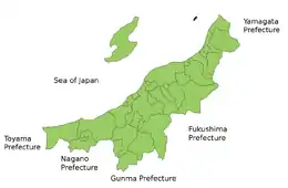
Awashima (粟島) is an island in the Sea of Japan.[1] The island is located approximately 30 kilometres (19 mi) west of the city of Murakami in northern Niigata Prefecture.
Awashima is administratively the village of Awashimaura under Iwafune District of Niigata Prefecture. As of 2020, the island's population is 353.[2]
History
Awashima has been inhabited since at least the Jōmon period, as archaeologists have found Jōmon period pottery shards in five locations on the islands east coast. However, no evidence of inhabitation from the Yayoi period or the Kofun period has yet been discovered. The name of the island first appears in a verse in the Nara period Man'yōshū poetry anthology, at which time the island was on the frontier of the Yamato state with the Emishi. The Matsura clan of northern Kyushu, noted pirates and sea traders, began to occupy the eastern shore of the island from the 9th century, gradually pushing the Emishi out. During the Edo period, the island passed between Murakami Domain, Shonai Domain and direct control by the Tokugawa Shogunate several times. During the Boshin War, the Schnell brothers offloaded weapons for Shonai Domain at Awashima. After the Meiji restoration, the village of Asahimaura was created in 1909 as part of Iwafune, District, Niigata Prefecture. The epicentre of the 1964 Niigata earthquake was near Awashima.
Climate
| Climate data for Awashima (1991−2020 normals, extremes 1978−present) | |||||||||||||
|---|---|---|---|---|---|---|---|---|---|---|---|---|---|
| Month | Jan | Feb | Mar | Apr | May | Jun | Jul | Aug | Sep | Oct | Nov | Dec | Year |
| Record high °C (°F) | 13.7 (56.7) |
18.8 (65.8) |
20.2 (68.4) |
26.6 (79.9) |
29.6 (85.3) |
31.8 (89.2) |
36.0 (96.8) |
37.0 (98.6) |
36.5 (97.7) |
29.6 (85.3) |
23.3 (73.9) |
18.7 (65.7) |
37.0 (98.6) |
| Mean daily maximum °C (°F) | 5.5 (41.9) |
5.8 (42.4) |
9.1 (48.4) |
14.5 (58.1) |
19.7 (67.5) |
23.5 (74.3) |
27.1 (80.8) |
29.3 (84.7) |
25.6 (78.1) |
20.0 (68.0) |
14.2 (57.6) |
8.7 (47.7) |
16.9 (62.5) |
| Daily mean °C (°F) | 3.1 (37.6) |
3.0 (37.4) |
5.6 (42.1) |
10.3 (50.5) |
15.4 (59.7) |
19.6 (67.3) |
23.6 (74.5) |
25.5 (77.9) |
22.0 (71.6) |
16.5 (61.7) |
11.0 (51.8) |
5.9 (42.6) |
13.5 (56.2) |
| Mean daily minimum °C (°F) | 0.5 (32.9) |
0.2 (32.4) |
2.1 (35.8) |
6.3 (43.3) |
11.5 (52.7) |
16.3 (61.3) |
20.9 (69.6) |
22.4 (72.3) |
18.7 (65.7) |
12.9 (55.2) |
7.6 (45.7) |
3.0 (37.4) |
10.2 (50.4) |
| Record low °C (°F) | −5.8 (21.6) |
−6.8 (19.8) |
−3.2 (26.2) |
−0.8 (30.6) |
3.9 (39.0) |
9.5 (49.1) |
12.8 (55.0) |
16.1 (61.0) |
10.5 (50.9) |
5.9 (42.6) |
−0.6 (30.9) |
−4.3 (24.3) |
−6.8 (19.8) |
| Average precipitation mm (inches) | 138.2 (5.44) |
92.4 (3.64) |
93.3 (3.67) |
85.6 (3.37) |
95.5 (3.76) |
111.8 (4.40) |
190.0 (7.48) |
154.7 (6.09) |
156.1 (6.15) |
155.3 (6.11) |
156.1 (6.15) |
170.5 (6.71) |
1,602.8 (63.10) |
| Average precipitation days (≥ 1.0 mm) | 23.5 | 18.1 | 16.4 | 11.9 | 10.4 | 9.5 | 12.3 | 9.9 | 12.5 | 13.9 | 18.1 | 22.4 | 178.9 |
| Mean monthly sunshine hours | 52.1 | 75.2 | 140.4 | 195.1 | 222.5 | 203.8 | 183.8 | 226.5 | 169.1 | 145.9 | 91.8 | 53.9 | 1,763.1 |
| Source: Japan Meteorological Agency[3][4] | |||||||||||||
Important Bird Area
The island has been recognised as an Important Bird Area (IBA) by BirdLife International because it supports a large breeding colony of streaked shearwaters.[5]
Minor Planet
A minor planet 13039 Awashima has been named after the island.
See also
Notes
- ↑ Nussbaum, Louis-Frédéric. (2005). "Izu Shotō," Japan Encyclopedia, p. 412.
- ↑ Awashimaura population statistics
- ↑ 観測史上1~10位の値(年間を通じての値). JMA. Retrieved March 6, 2022.
- ↑ 気象庁 / 平年値(年・月ごとの値). JMA. Retrieved March 6, 2022.
- ↑ "Awashima Island". BirdLife Data Zone. BirdLife International. 2021. Retrieved 25 January 2021.
References
- Teikoku's Complete Atlas of Japan, Teikoku-Shoin., Ltd. Tokyo 1990, ISBN 4-8071-0004-1
External links
![]() Media related to Awashima at Wikimedia Commons
Media related to Awashima at Wikimedia Commons