Bělá | |
|---|---|
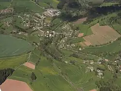 Aerial view | |
 Flag  Coat of arms | |
 Bělá Location in the Czech Republic | |
| Coordinates: 50°32′2″N 15°26′42″E / 50.53389°N 15.44500°E | |
| Country | |
| Region | Liberec |
| District | Semily |
| First mentioned | 1542 |
| Area | |
| • Total | 7.76 km2 (3.00 sq mi) |
| Elevation | 378 m (1,240 ft) |
| Population (2023-01-01)[1] | |
| • Total | 279 |
| • Density | 36/km2 (93/sq mi) |
| Time zone | UTC+1 (CET) |
| • Summer (DST) | UTC+2 (CEST) |
| Postal code | 514 01 |
| Website | www |
Bělá is a municipality and village in Semily District in the Liberec Region of the Czech Republic. It has about 300 inhabitants.
References
External links
Wikimedia Commons has media related to Bělá (Semily District).
This article is issued from Wikipedia. The text is licensed under Creative Commons - Attribution - Sharealike. Additional terms may apply for the media files.