Ballymoe
Béal Átha Mó (Irish) | |
|---|---|
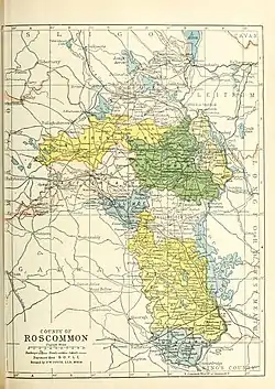
 Barony map of County Roscommon, 1900; Ballymoe is coloured blue, in the centre. | |
| Sovereign state | Ireland |
| Province | Connacht |
| County | Roscommon |
| Area | |
| • Total | 94.24 km2 (36.39 sq mi) |
Ballymoe (Irish: Béal Átha Mó[1]) is a barony in County Roscommon, Ireland.[2][3]
Etymology
Ballymoe barony is named after Ballymoe town, County Galway; the name means "mouth of the ford of Mogh"; Mogh is a legendary figure linked to Queen Medb.
Geography
Ballymoe barony is located in the centre of County Roscommon, north of the River Suck.
History
Donamon Castle is located in Ballymoe; it was a centre of the Ó Fiannachta (O'Feenaghty). Also in this area were the O'Concheanainn (O'Concannon), chiefs of the Uí Díarmata.[4]
There was originally a single large barony, named Ballymoe and part of County Galway. Later, about one-fifth of the barony's area — the part north of the River Suck — was given to County Roscommon.
Richard Malone, 1st Baron Sunderlin (c. 1738 – 1816) was a landowner in the area.[5] It was the site of agrarian trouble in the 1840s.[6]
References
- ↑ "Béal Átha Mó/Ballymoe". Logainm.ie.
- ↑ Weld, Isaac; Society, Royal Dublin (1832). Statistical survey of the county of Roscommon. Printed by R. Graisberry. p. 4 – via Internet Archive.
Ballymoe.
- ↑ "Drimtemple". www.libraryireland.com.
- ↑ "The Baronies of Ireland - Family History". sites.rootsweb.com.
- ↑ "Oran (Ballymoe)". landedestates.nuigalway.ie.
- ↑ Coleman, Anne (31 December 1999). Riotous Roscommon: Social Unrest in the 1840s. Irish Academic Press. ISBN 9780716526711 – via Google Books.
.jpg.webp)
