Barchovice | |
|---|---|
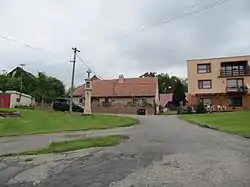
 Centre of Barchovice | |
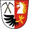
 Flag  Coat of arms | |
 Barchovice Location in the Czech Republic | |
| Coordinates: 49°56′40″N 14°58′9″E / 49.94444°N 14.96917°E | |
| Country | |
| Region | Central Bohemian |
| District | Kolín |
| First mentioned | 1340 |
| Area | |
| • Total | 17.74 km2 (6.85 sq mi) |
| Elevation | 329 m (1,079 ft) |
| Population (2023-01-01)[1] | |
| • Total | 255 |
| • Density | 14/km2 (37/sq mi) |
| Time zone | UTC+1 (CET) |
| • Summer (DST) | UTC+2 (CEST) |
| Postal code | 281 63 |
| Website | www |
Barchovice is a municipality and village in Kolín District in the Central Bohemian Region of the Czech Republic. It has about 300 inhabitants.
Administrative parts
Villages of Hryzely and Radlice are administrative parts of Barchovice.
Geography
Barchovice is located about 18 km (11 mi) southwest of Kolín and 33 km (21 mi) southeast of Prague. The municipal territory lies in three geomorphological regions: the eastern part lies in the Upper Sázava Hills, the central part lies in a tip of the Central Elbe Table, and the western part extends into the Benešov Uplands. The highest point is the hill Kamenný vrch at 456 m (1,496 ft) above sea level. The eastern municipal border is formed by the Výrovka River.
History
The first written mention of Barchovice is from 1340. The area was divided into two parts, which belonged to different estates (Zásmuky and Kostelec estates) with different owners. The larger part of Barchovice belonged to the Zásmuky estate and its most notable owners were the Sternberg family, who held it from 1653 to 1848.[2]
Sights
Barchovice is poor in monuments. There are three pillared stone belfries, one in each village.[3]
References
- ↑ "Population of Municipalities – 1 January 2023". Czech Statistical Office. 2023-05-23.
- ↑ "Dějiny obce Barchovice" (in Czech). Obec Barchovice. Retrieved 2022-10-17.
- ↑ "Územní plán Barchovice" (in Czech). Obec Barchovice. pp. 9–16. Retrieved 2022-10-17.