17°00′N 24°00′W / 17.000°N 24.000°W

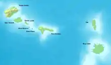
Barlavento islands (yellow) within Cape Verde

Barlavento Islands
The Barlavento Islands (Portuguese: Ilhas de Barlavento, literally, the Windward Islands) is the northern group of the Cape Verde archipelago.[1] It presents as two sub-groups:
- in the west: Santo Antão, São Vicente,[lower-alpha 1] São Nicolau, Santa Luzia and islets Branco and Raso are volcanic and somewhat rocky yet quite widely capable of supporting semi-arid agriculture.
- in the east: Sal[lower-alpha 2] and Boa Vista[lower-alpha 3] are lightly-hilled, desert islands whose economies were based on salt and rely on fishing and tourism, having more in common with the Sotavento island Maio.
The total land mass is 2,239 km2 (864 sq mi).[1] Spanning from longitude -22.67 to -25.36 (implying west of the Prime Meridian), the group sits in the Trade winds, specifically at the optional southern turn or tack termed by European sailors a key point of the Volta do Mar. The islands are west of Cap-Vert at -17.31 west, in turn the westernmost point of Africa on the outskirts of Dakar (the capital of Senegal).
See also
Notes
- ↑ plus islet Ilhéu dos Pássaros
- ↑ plus islet Ilhéu Rabo de Junco
- ↑ plus islets Ilhéu de Sal-Rei and Ilhéu do Baluarte
References
- 1 2 Valor simbólico do centro histórico da Praia, Lourenço Conceição Gomes, Universidade Portucalense, 2008, p. 58-59
Further reading
Wikimedia Commons has media related to Barlavento (Cape Verde).
- Barlavento Islands article at Britannica Online, accessed on 1 January 2010
This article is issued from Wikipedia. The text is licensed under Creative Commons - Attribution - Sharealike. Additional terms may apply for the media files.