| Bears Paw Mountains | |
|---|---|
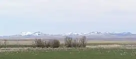
 Bears Paw Mountains as seen from near Virgelle, Montana | |
| Highest point | |
| Peak | Baldy Mountain |
| Elevation | 6,916 ft (2,108 m)[1] |
| Geography | |

| |
| Country | United States |
| State | Montana |
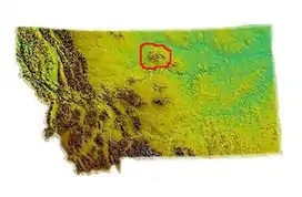
| Range coordinates | 48°12.5′N 109°31.05′W / 48.2083°N 109.51750°W |
| Geology | |
| Age of rock | Late Cretaceous |
The Bears Paw Mountains (Bear Paw Mountains, Bear's Paw Mountains or Bearpaw Mountains)[2] are an insular-montane island range in the Central Montana Alkalic Province in north-central Montana, United States, located approximately 10 miles south of Havre, Montana. Baldy Mountain, which rises 6,916 feet (2,108 m) above sea level, is the highest peak in the range. The Bears Paw Mountains extend in a 45-mile arc between the Missouri River and Rocky Boy Indian Reservation south of Havre.
Name

Locals refer to the range as the Bearpaws.[3] Indigenous names include Assiniboine: Waną́be, lit. 'bear paws',[4] Crow: Daxpitcheeischikáate, lit. 'bear's little hand',[5] and Gros Ventre: ʔɔɔwɔ́hʔoouh, lit. 'there are many buttes'.[6]
While highway signs designate the range as the Bears Paw Mountains, historically, the names Bearpaw Mountains and Bear Paw Mountains also have been used, including on early state maps of the region. The U.S. Geological Survey continues to use Bearpaw Mountains on publications.
Geology

The core of the Bearpaws are composed of extensive Eocene aged igneous intrusions left over from one of the largest eruptive centers in the Central Montana Alkaline Province. Shonkinite, latite, & tinguatite are among the most common igneous rock compositions found in the Bearpaws.
The Cretaceous Bearpaw Formation outcrops in these mountains, and is named for the range.
History
Chief Joseph of the Nez Perce surrendered to Col. Nelson Miles in the foothills of the Bear's Paw Mountains in October 1877 after the Battle of Bear Paw.[7]
Native American legend
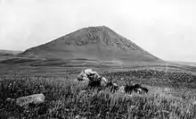
Native oral history ties the name to a lone hunter in search of deer to feed his clan. He killed a deer but, while returning to the prairie, encountered a bear. The bear held the hunter to the ground, and the hunter appealed to the Great Spirit to release him. The Great Spirit filled the heavens with lightning and thunder, striking the bear dead and severing its paw to release the hunter. Looking at Box Elder Butte, one can see the paw, and Centennial Mountain to the south resembles a reclining bear.[8]
See also
References
- ↑ "Baldy Mountain". Geographic Names Information System. United States Geological Survey, United States Department of the Interior. Retrieved 2019-05-17.
- ↑ "Bears Paw Mountains". Geographic Names Information System. United States Geological Survey, United States Department of the Interior. Retrieved 2019-05-17.
- ↑ Montana Place Names Companion Website Aarstad, Rich, Ellie Arguimbau, Ellen Baumler, Charlene Porsild, and Brian Shovers. Montana Place Names from Alzada to Zortman. Montana Historical Society Press
- ↑ "AISRI Dictionary Database Search--prototype version. Assiniboine. "Montana"". Retrieved 2012-05-26.
- ↑ "Apsáalooke Place Names Database". Little Big Horn College Library. Retrieved 2019-05-17.
- ↑ Cowell, A.; Taylor, A.; Brockie, T. "Gros Ventre ethnogeography and place names: A diachronic perspective". Anthropological Linguistics. 58 (2): 132–170. doi:10.1353/anl.2016.0025.
- ↑ Greene, Jerome A. (2000). "13". Nez Perce Summer 1877: The U.S. Army and the Nee-Me-Poo Crisis. Helena, MT: Montana Historical Society Press. ISBN 0-917298-68-3.
- ↑ "An Island on the Plains: the Bears Paw Mountains" (PDF). Montana Department of Transportation. Archived from the original (PDF) on June 20, 2010.
External links
- Montana Historical Society
 Media related to Bears Paw mountains at Wikimedia Commons