Belmont Township | |
|---|---|
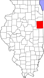
 Location in Iroquois County | |
 Iroquois County's location in Illinois | |
| Coordinates: 40°43′53″N 87°42′08″W / 40.73139°N 87.70222°W | |
| Country | United States |
| State | Illinois |
| County | Iroquois |
| Established | November 6, 1855 |
| Area | |
| • Total | 36.33 sq mi (94.1 km2) |
| • Land | 36.33 sq mi (94.1 km2) |
| • Water | 0 sq mi (0 km2) 0% |
| Elevation | 650 ft (198 m) |
| Population (2010) | |
| • Estimate (2016)[1] | 2,497 |
| • Density | 71.9/sq mi (27.8/km2) |
| Time zone | UTC-6 (CST) |
| • Summer (DST) | UTC-5 (CDT) |
| ZIP codes | 60953, 60966, 60970, 60974 |
| FIPS code | 17-075-05014 |
Belmont Township is one of twenty-six townships in Iroquois County, Illinois, United States. As of the 2010 census, its population was 2,610 and it contained 1,188 housing units.[2]
Geography
According to the 2010 census, the township has a total area of 36.33 square miles (94.1 km2), all land.[2]
Cities, towns, villages
Unincorporated towns
- Coaler at 40°44′50″N 87°43′59″W / 40.747258°N 87.733088°W
- Woodland Junction at 40°41′50″N 87°43′51″W / 40.697258°N 87.730864°W
(This list is based on USGS data and may include former settlements.)
Cemeteries
The township contains these four cemeteries: Belmont, Body, Iroquois Memorial Park and Keen.
Major highways
Airports and landing strips
- Newman Landing Strip
Landmarks
- Legion Park
Demographics
| Census | Pop. | Note | %± |
|---|---|---|---|
| 2016 (est.) | 2,497 | [1] | |
| U.S. Decennial Census[3] | |||
School districts
- Iroquois County Community Unit School District 9
Political districts
- Illinois's 15th congressional district
- State House District 105
- State Senate District 53
References
- "Belmont Township, Iroquois County, Illinois". Geographic Names Information System. United States Geological Survey, United States Department of the Interior. Retrieved January 17, 2010.
- United States Census Bureau 2007 TIGER/Line Shapefiles
- United States National Atlas
- 1 2 "Population and Housing Unit Estimates". Retrieved June 9, 2017.
- 1 2 "Population, Housing Units, Area, and Density: 2010 - County -- County Subdivision and Place -- 2010 Census Summary File 1". United States Census. Archived from the original on February 12, 2020. Retrieved May 28, 2013.
- ↑ "Census of Population and Housing". Census.gov. Retrieved June 4, 2016.
External links
Places adjacent to Belmont Township, Iroquois County, Illinois | |
|---|---|
Municipalities and communities of Iroquois County, Illinois, United States | ||
|---|---|---|
| Cities | Map of Illinois highlighting Iroquois County | |
| Villages | ||
| Townships | ||
| Unincorporated communities | ||
| Footnotes | ‡This populated place also has portions in an adjacent county or counties | |
This article is issued from Wikipedia. The text is licensed under Creative Commons - Attribution - Sharealike. Additional terms may apply for the media files.