41°54′N 90°24′W / 41.9°N 90.4°W

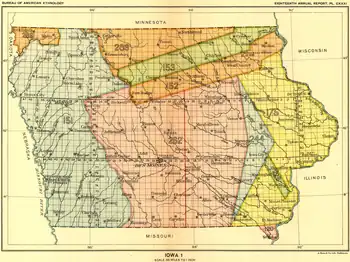
The Black Hawk Purchase, also known as the Forty-Mile Strip or Scott's Purchase, extended along the West side of the Mississippi River from the north boundary of Missouri North to the Upper Iowa River in the northeast corner of Iowa. It was fifty miles wide at the ends, and forty in the middle, and is sometimes called the "Forty-Mile Strip".[1] The land, originally owned by the Sauk, Meskwaki (Fox), and Ho-Chunk (Winnebago) Native American people, was acquired by treaty following their defeat by the United States in the Black Hawk War. After being defeated the Sauk and Mesquakie were forced to relinquish another 2.5 million hectares or (6 million acres) and give up their rights to plant, hunt, or fish on the land. The purchase was made for $640,000 on September 21, 1832 and was named for the chief Black Hawk, who was held prisoner at the time the purchase was completed. The Black Hawk Purchase contained an area of 6 million acres (24,000 km²), and the price was equivalent to 11 cents/acre ($26 per km²).[2] The region is bounded on the East by the Mississippi River and includes Dubuque, Fort Madison, and present-day Davenport.
About
The treaty was made by General Winfield Scott and the Governor of Illinois, John Reynolds, at what is now Davenport, Iowa, on the west bank of the Mississippi River. The agreement was ratified February 13, 1833, and officially went into effect on June 1, 1833, when the territory became the first section of what is now Iowa to be opened for settlement by non-Native Americans: United States citizens, or Europeans.
Description
In "Treaty With the Sauk and Foxes, 1832", the land was described as follows: all the lands to which the said tribes have title, or claim, (with the exception of the reservation hereinafter made,) included within the following bounds, to wit: Beginning on the Mississippi River at a point where the Sac and Fox northern boundary line, as established by the second article of the Fourth Treaty of Prairie du Chien, July, 1830, strikes said river; thence up said boundary line to a point 50 miles [80 km] from the Mississippi measured on said line; thence in a right line to the nearest point on the Cedar River, of Iowa, 40 miles [60 km] from the Mississippi; thence in a right line to a point in the northern boundary of the State of Missouri, 50 miles [80 km] measured on said boundary from the Mississippi River; thence by the last mentioned boundary to the Mississippi River, and by the western shore of said river to the place of beginning."
According to The Making of Iowa (1900), "The Black Hawk Purchase extended along the west side of the Mississippi River from the north boundary of Missouri north to the Upper Iowa River. The Upper Iowa River is in the northeast corner of Iowa, and must not be confounded with the Iowa River in the southern half of the state. This is than where the tract extended from Missouri nearly to Minnesota. It was 50 miles [80 km] wide at the ends, and 40 in the middle."
According to The History of Jefferson County, Iowa (1879), "This was a strip of land on the west bank of the Mississippi River, the western boundary of which commenced at the southeast corner of the present county of Davis; thence to a point on Cedar River, near the northeast corner of Johnson County; thence northwest to the neutral grounds of the Winnebagoes; thence to the Mississippi to a point above Prairie du Chien..." Still another history describes it as extending from the Yellow River in the north to the Des Moines River in the south.
Two areas were held back as special awards; one was assigned to the chief Keokuk and his Sauk people in thanks for their neutrality (later known as Keokuk's Reserve); the other was given to "half-breed" translator Antoine LeClaire. (Note: LeClaire's reserve was different from the Half-Breed Tract, which was designated and set aside west of the Missouri River before the Black Hawk Purchase.)
The land of the purchase was successively governed by the legislatures of the Michigan Territory, the Wisconsin Territory, Iowa Territory and finally Iowa.
The Black Hawk Purchase was followed by the so-called Second Black Hawk Purchase (1837) and New Purchase (1842).
See also
References
- ↑ "Archived copy". Archived from the original on 2010-12-30. Retrieved 2009-04-01.
{{cite web}}: CS1 maint: archived copy as title (link) - ↑ "The Making of Iowa Chapter III The Birth of a State". Iowa Genealogy Web. Retrieved 2009-08-12.
External links
- A.T. Andreas, Illustrated Historical Atlas of the State of Iowa, 1875: "Indians of Iowa, Black Hawk, The Black Hawk War, The Black Hawk Purchase, Keokuk's Reserve, The Sac and Fox Agency, Indian Treaties", scanned at Rootsweb
- A.T. Andreas, Illustrated Historical Atlas of the State of Iowa, 1875: "Territorial Relations, Pike's Expedition, Spanish Grants, The Half-Breed Tract", scanned at Rootsweb
- "Treaty with the Sauk and Foxes, 1832" Archived 2017-09-22 at the Wayback Machine, Treaty authorizing the Black Hawk Purchase, Digital Library, Oklahoma State University
- "Map of the Black Hawk Purchase"
- Vogt, Michael. "Black Hawk War.", Iowa Path Ways, Johnston, Iowa, Website Accessed October 16, 2014,
- Lewis, James. "Background." Black Hawk War of 1832. Davenport, Iowa, Website Accessed October 16, 2014
- Not Displayed, "Making of Iowa.” How the Indians Lost Iowa, Website Accessed October 16, 2014.
- Wesson, Sarah. "Makataimeshekiakiak: Black Hawk and His War." Black Hawk. Accessed October 16, 2014.