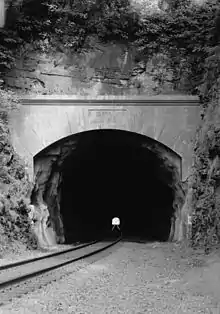
 East end of tunnel, looking NW | |
| Overview | |
|---|---|
| Location | Phoenixville, Pennsylvania |
| Coordinates | 40°08′45″N 75°30′56″W / 40.14583°N 75.51556°W |
| Status | Active |
| System | Reading Railroad (original) Norfolk Southern (current) |
| Operation | |
| Constructed | 1835–1837 |
| Opened | 1838 |
| Character | Freight |
| Technical | |
| Length | 1,932 feet (589 m) |
| No. of tracks | Double (original) Single (current) |
| Track gauge | 4 ft 8+1⁄2 in (1,435 mm) |
| Tunnel clearance | 17 feet (5.2 m) |
The Black Rock Tunnel is an active rail road tunnel of the old Reading Railroad. The 1835 tunnel was the third rail tunnel constructed in the United States, and is the third oldest still in use.[1] The tunnel is also notable as being the first for which shafts were sunk during construction.[2] The tunnel is cut through a hill in Phoenixville, Pennsylvania, United States. The tunnel and line are now owned by Norfolk Southern as part of its Harrisburg Line.
The Black Rock Tunnel was constructed between 1835 and 1837 and opened in 1838. W. Hasell Wilson was the resident engineer in charge.[2] The tunnel was originally 1,932 feet (589 m) long, 19 feet (5.8 m) wide, and 17 feet (5.2 m) high.[3] The tunnel passes 122 feet (37 m) below the top of the hill.[1] A then-unique feature of the tunnel's construction was the sinking of six, 7-foot (2.1 m) diameter shafts, tangent to the tunnel cross section. These shafts were spaced at 100-foot (30 m) intervals to correct errors in the tunnel alignment.[2] Construction of the tunnel cost an estimated $178,992, equal to $4,918,924 today.[4]
Noted local miner, geologist and palaentologist Charles M. Wheatley examined the rock excavated from the tunnel and identified many previously unknown fossilized species, some of which now bear his name.[5]
In 1858 and 1859 the Black Rock and Flat Rock Tunnels were widened to accommodate the wider rolling stock from the Lebanon Valley Branch. The spacing between the tracks was increased from 4 feet (1.2 m) to 6 feet (1.8 m). The widening of the tunnel was the first project to employ electric detonation of multiple explosive charges.[6]
The northern end of the tunnel is high on a steep bank of the Schuylkill River so the rail line makes a dramatic transition from tunnel to bridge. The ends of the Black Rock Tunnel are located at 40°08′51″N 75°31′06″W / 40.14750°N 75.51833°W and 40°08′39″N 75°30′46.5″W / 40.14417°N 75.512917°W.
See also
References
- 1 2 Treese, Lorett (2003). Railroads of Pennsylvania: fragments of the past in the Keystone landscape. Stackpole Books. p. 41. ISBN 0-8117-2622-3. Retrieved 2009-11-07.
- 1 2 3 Drinker, Henry Sturgis (1883). A Treatise on Explosive Compounds, Machine Rock Drills and Blasting. New York: John Wiley & Sons. pp. 29–30. Retrieved 2009-11-07.
- ↑ Pennypacker, Samuel Whitaker (1872). Annals of Phoenixville and Its Vicinity: From the Settlement to the Year 1871. Phoenixville, PA: Bavis & Pennypacker, printers. p. 178.
- ↑ Ringwalt, John Luther (1888). Development of Transportation Systems in the United States. Philadelphia: Published by the author. p. 87. Retrieved 2009-11-07.
- ↑ Pennypacker, p. 179.
- ↑ "From Branch Line to Main Line: The Story of the Lebanon Valley Branch" (PDF). The RSME Timetable. Reading Society Model Engineers: 5. May 2007. Archived from the original (PDF) on 2008-11-20. Retrieved 2009-11-07.
External links
- Historic American Engineering Record (HAER) No. PA-520, "Philadelphia & Reading Railroad, Black Rock Tunnel"
- Black Rock Tunnel stereo image pair at the New York Public Library
- Black Rock Tunnel on RailPictures.net