Blanton, Oklahoma | |
|---|---|
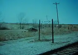 Blanton railroad stop in the mid-1990s | |
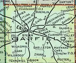 1909 map of Garfield County, Oklahoma with Blanton. | |
| Coordinates: 36°25′38″N 97°55′35″W / 36.42722°N 97.92639°W | |
| Country | United States |
| State | Oklahoma |
| County | Garfield |
| Elevation | 1,240 ft (400 m) |
| Time zone | UTC-6 (CST) |
| • Summer (DST) | UTC-5 (CDT) |
| Area code | 580 |
| GNIS feature ID | 1100216[1] |
Blanton is an unincorporated community[2] in Garfield County, Oklahoma, United States. It was a rail stop for two rail lines,[3] one of which used to transport grain until the mid-1990s.[4] It was named after Denver, Enid and Gulf Railroad (DE&G) executive W. B. Blanton.[5]
History
As early as 1909, Blanton was a rail stop for the St. Louis-San Francisco Railway.[3]
A second rail line existed at Blanton, running to Kiowa, Kansas. This line, originally built for the DE&G in 1904 and 1905[6] and later sold to the Atchison, Topeka and Santa Fe, was used to transport grain until the mid-1990s.[4] An entity called the K & E Railway Company (K&E) acquired the then-unused Blanton to Kiowa branch from the Santa Fe in 1996; but, finding no interest in area grain companies to reactivate the line rather than continuing truck shipments to Enid, the K&E applied for and was granted permission later in the year to abandon the line.[7]
Geography
Blanton is located at 36°25′38″N 97°55′35″W / 36.42722°N 97.92639°W, 3.4 miles (5.5 km) west-northwest of Enid. It is a part of the Lower Cimarron-Skeleton Watershed.[8]
Blanton is currently located on mile 548.2 of the main track of BNSF Railway's Texas Division.[9]
References
- 1 2 U.S. Geological Survey Geographic Names Information System: Blanton, Oklahoma
- ↑ "Blanton, Oklahoma". Geographic Names Information System. United States Geological Survey. Retrieved August 4, 2008.
- 1 2 Historical Maps of Oklahoma, University of Alabama (accessed May 30, 2010).
- 1 2 The Surface Transportation Board: Docket Number: AB_480_0_X Archived 2016-08-08 at the Wayback Machine (accessed May 30, 2010).
- ↑ Cammalleri, Joseph A., Guthrie, Oklahoma: Always a Railroad Town, pp. 43-44
- ↑ George, Preston; Wood, Sylvan R. (January 1943). "The Railroads of Oklahoma". Railway and Locomotive Historical Society Bulletin. 60: 38. JSTOR 43516811.
- ↑ "Abandonment Exemption". Surface Transportation Board. Retrieved July 6, 2020.
- ↑ U.S. EPA. "Lower Cimarron-Skeleton Watershed -- 11050002. Surf Your Watershed". Retrieved August 4, 2008.
- ↑ BNSF Railway. "Texas Division Map, January 1, 2005" (PDF). Archived from the original (PDF) on October 4, 2008. Retrieved August 5, 2008.
Municipalities and communities of Garfield County, Oklahoma, United States | ||
|---|---|---|
| Cities | 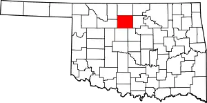 Map of Oklahoma highlighting Garfield County | |
| Towns | ||
| CDP | ||
| Unincorporated communities | ||