Bolton, Massachusetts | |
|---|---|
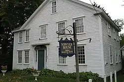
 Sawyer House, Bolton Historical Society | |
 Flag  Seal | |
 Location in Worcester County and the state of Massachusetts. | |
| Coordinates: 42°26′00″N 71°36′30″W / 42.43333°N 71.60833°W | |
| Country | United States |
| State | Massachusetts |
| County | Worcester |
| Settled | 1682 |
| Incorporated | 1738 |
| Government | |
| • Type | Open town meeting |
| • Town Administrator | Donald (Don) Lowe[1] |
| • Board of Selectmen | Stanley Wysocki Jonathan Keep Robert Czekanski |
| Area | |
| • Total | 20.0 sq mi (51.8 km2) |
| • Land | 19.9 sq mi (51.6 km2) |
| • Water | 0.1 sq mi (0.2 km2) |
| Elevation | 387 ft (118 m) |
| Population (2020) | |
| • Total | 5,665 |
| • Density | 280/sq mi (110/km2) |
| Time zone | UTC-5 (Eastern) |
| • Summer (DST) | UTC-4 (Eastern) |
| ZIP code | 01740 |
| Area code | 351 / 978 |
| FIPS code | 25-06365 |
| GNIS feature ID | 0618357 |
| Website | www.townofbolton.com |
Bolton is a town in Worcester County, Massachusetts, United States. Bolton is in central Massachusetts, located 25 miles west-northwest of downtown Boston along Interstate 495. It is within Greater Boston and MetroWest regions. The population was 5,665 at the 2020 census.[2]
Settled in the 1600s and incorporated in 1738, the town is still home to many farms and apple orchards as well the well-known Nashoba Valley Winery[3] and The International Golf Club, which has hosted several major tournaments.[4] The Bolton Flats Wildlife Management Area is largely located in the town near the Nashua River and Still River[5] as well as many other parks and conservation areas.[6]
History

The land in what is now Bolton was formerly part of the town of Lancaster until Bolton seceded along the Still River, where the current boundary line still stands.[7] The town of Bolton was incorporated on June 24, 1738, following an influx of settlers and was named after the Duke of Bolton.[8]
Prior to its incorporation, the area was settled by English farmers in the 1600s near where the Nashaway tribe fished along the Nashua River.[9] Town historian Esther Whitcomb, descendant of one of Bolton's earliest documented settlers, cites the recorded birth of a son, Hezekiah, to Josiah Whitcomb in 1681 as one of the earliest recorded births in the area.[10] By 1711, according to Whitcomb, more than 150 people were living on Bolton soil, despite a local history of Indian uprisings and one massacre. Many early houses were protected by flankers, and were designated as garrisons.[11] Bolton's history is largely reflective of early settlement patterns in the central Massachusetts area and the conflicts with King Philip (Metacom) and his Indian soldiers.[12]
During the American Revolution Bolton farmers erected a liberty pole at the town center and largely supported the revolutionary cause. General John Whitcomb of Bolton was elected the first Major-General of the Massachusetts Army at the third Provincial Congress in 1775. He was a minuteman leader at the Battles of Lexington and Concord and the Battle of Bunker Hill.[13] By the Civil War in the 1860s Bolton residents had formed an abolitionist society, and twenty-one Bolton residents died fighting for the Union.[14] The Bolton Fair was founded in Bolton in 1874 as an agricultural fair, but the fairgrounds were later moved to nearby Lancaster in 2004 where it is still held annually.[15]
In the 1920s Bolton was used as a setting and mentioned a number of times in H.P. Lovecraft's fiction: as a setting in his Herbert West—Reanimator, and also mentioned in his The Rats in the Walls and The Colour out of Space. However, H.P. Lovecraft's Bolton was located on the North Shore near Ipswich, Massachusetts, and was described as a factory town bearing little resemblance to the actual town.[16]
Geography
According to the United States Census Bureau, the town has a total area of 20.0 square miles (52 km2), of which 19.9 square miles (52 km2) is land and 0.1 square miles (0.26 km2), or 0.35%, is water.
Demographics
| Year | Pop. | ±% |
|---|---|---|
| 1850 | 1,263 | — |
| 1860 | 1,348 | +6.7% |
| 1870 | 1,014 | −24.8% |
| 1880 | 903 | −10.9% |
| 1890 | 827 | −8.4% |
| 1900 | 770 | −6.9% |
| 1910 | 764 | −0.8% |
| 1920 | 708 | −7.3% |
| 1930 | 764 | +7.9% |
| 1940 | 775 | +1.4% |
| 1950 | 956 | +23.4% |
| 1960 | 1,264 | +32.2% |
| 1970 | 1,905 | +50.7% |
| 1980 | 2,530 | +32.8% |
| 1990 | 3,134 | +23.9% |
| 2000 | 4,148 | +32.4% |
| 2010 | 4,897 | +18.1% |
| 2020 | 5,665 | +15.7% |
| 2022 | 5,728 | +1.1% |
| * = population estimate. Source: United States census records and Population Estimates Program data.[17][18][19][20][21][22][23][24][25][26][27] | ||
As of the census[28] of 2010, there were 4,897 people, 1,670 households, and 1,391 families residing in the town. The population density was 246.1 inhabitants per square mile (95.0/km2). There were 1,738 housing units at an average density of 87.3 per square mile (33.7/km2). The racial makeup of the town was 94.9% White, 0.5% African American, 0.1% Native American, 2.7% Asian, 0.02% Pacific Islander, 0.2% from other races, and 1.6% from two or more races. Hispanic or Latino of any race were 1.8% of the population.
There were 1,670 households, out of which 43.7% had children under the age of 18 living with them, 74.3% were married couples living together, 2.8% had a male householder with no husband present, 6.2% had a female householder with no husband present, and 16.7% were non-families. The householders of 12.1% of all households were living alone and the householders of 4.9% of households were living alone who was 65 years of age or older. The average household size was 2.93 and the average family size was 3.22.
In the town, the population was spread out, with 31.2% of the population 19 and under, 3.4% from 20 to 24, 19.7% from 25 to 44, 36.3% from 45 to 64, and 9.4% who were 65 years of age or older. The median age was 38 years. For every 100 females, there were 100.8 males. For every 100 females age 18 and over, there were 96.1 males.
As of 2015, the median income for a household in the town was $147,446, and the median income for a family was $155,063. Males had a median income of $101,042 versus $71,905 for females. The per capita income for the town was $51,791.[29] About 1.3% of families and 1.8% of the population were below the poverty line, including 1.6% of those under age 18 and 2.0% of those age 65 or over.
Arts and culture
National Historic Places
- Bolton Center Historic District, includes historic civic, religious and commercial buildings along Route 117
- Pan Burying Ground, est. 1822 contains a notable seven-chambered group tomb
- Pan Historic District, includes a large collection of rural Federal style and colonial architecture
- Whitcomb Inn and Farm, ca. 1708, possibly the oldest surviving house in Bolton
Government
| County-level state agency heads | |
|---|---|
| Clerk of Courts: | Dennis P. McManus (D) |
| District Attorney: | Joe Early Jr. (D) |
| Register of Deeds: | Katie Toomey (D) |
| Register of Probate: | Stephanie Fattman (R) |
| County Sheriff: | Lew Evangelidis (R) |
| State government | |
| State Representative(s): | Kate Hogan (D) |
| State Senator(s): | Dean Tran (R) |
| Governor's Councilor(s): | Jen Caissie (R) |
| Federal government | |
| U.S. Representative(s): | Lori Trahan (D) (3rd District), |
| U.S. Senators: | Elizabeth Warren (D), Ed Markey (D) |
Education
Bolton is a member of the Nashoba Regional School District, also serving the towns of Lancaster and Stow. Bolton is home to Florence Sawyer School (Pre-K–8) and Nashoba Regional High School, which was ranked by U.S. News as one of the top ten percent of schools nationally.[30]
Notable people
- Suzy Becker (born 1962), is an author, illustrator, entrepreneur, educator, and social activist
- William C. Edes (1856–1922), was a U.S. civil engineer who was the chairman for Alaskan Engineering Commission
- Bill Ezinicki (1924–2012), NHL hockey player, professional golfer, won three Stanley Cups with the Toronto Maple Leafs, inducted into PGA tour hall of fame New England Section in 1997
- Heather K. Gerken (born 1969), is the Dean and Sol & Lillian Goldman Professor of Law at Yale Law School
- Hal Gill (born 1975), former NHL player
- William Ellery Leonard (1876–1944), poet and author, professor at the University of Wisconsin's Dept. of English
- J. Sterling Livingston (1916–2010), was an American entrepreneur, management consultant, and professor at the Harvard Business School
- Frank L. McNamara Jr. (born 1947), is an American attorney who served as the United States Attorney for the District of Massachusetts
- Amos Nourse (1794–1877), United States Senator from Maine
- Karen O'Connor (born 1958), is an American equestrian who competes in three-day eventing
- Philip J. Philbin (1898–1972), member of the United States House of Representatives from Massachusetts's 3rd congressional district from 1943 to 1971
- Philip Phillips (1900-1994), Harvard archaeologist
- Wilbert Robinson (1864–1934), Baseball Hall of Fame manager nicknamed "Uncle Robbie", managed the Brooklyn Dodgers for 17 years
- Frederick A. Sawyer (1822–1891), United States Senator from South Carolina
- Samuel Stearns (1741–1809), astronomer and author
- William C. Sullivan (1912–1977), was a Federal Bureau of Investigation official
- Nathan Wilson (1758–1834), was a United States Representative from New York
References
- ↑ "New town administrator is fitting right in", Bolton Common, May 29, 2009.
- ↑ "Census - Geography Profile: Bolton town, Worcester County, Massachusetts". Retrieved November 6, 2021.
- ↑ "In Massachusetts' Nashoba Valley, Apple Orchards Are Just the Beginning". NECN. 2020-09-18. Retrieved 2024-01-11.
- ↑ "LIV Golf not returning to The International in Bolton in 2023 - The Boston Globe". BostonGlobe.com. Retrieved 2024-01-11.
- ↑ Bolton Reconnaissance Report, Mass. DCR, Freddom's Way Heritage Association, p. 10 (accessed 9/21/23) https://www.townofbolton.com/sites/g/files/vyhlif2836/f/uploads/boltonreconfinal.pdf
- ↑ "Bolton Trails – The website of Bolton Trails Committee. Maps, routes, paths and events on conservation land in Bolton Massachusetts". boltontrails.org. Retrieved 2024-01-11.
- ↑ Whitcomb, Esther Kimmon (1988). About Bolton. Bowie, MD: Heritage Books, Inc. ISBN 1-55613-105-4.
- ↑ Whitcomb
- ↑ "Contact and Plantation Periods (1500-1675) | Bolton MA". www.townofbolton.com. Retrieved 2024-01-11.
- ↑ Whitcomb
- ↑ Whitcomb
- ↑ Whitcomb
- ↑ "Federal Period (1776-1830) | Bolton MA". www.townofbolton.com. Retrieved 2024-01-11.
- ↑ "Early Industrial Period (1831-1872) | Bolton MA". www.townofbolton.com. Retrieved 2024-01-11.
- ↑ Doherty, Kevin (2010-08-10). "Bolton Fair stays true to agricultural roots". Sentinel and Enterprise. Retrieved 2024-01-11.
- ↑ Haden, David (July 15, 2013). "Lovecraft and Bolton, Mass".
- ↑ "Total Population (P1), 2010 Census Summary File 1". American FactFinder, All County Subdivisions within Massachusetts. United States Census Bureau. 2010.
- ↑ "Massachusetts by Place and County Subdivision - GCT-T1. Population Estimates". United States Census Bureau. Retrieved July 12, 2011.
- ↑ "1990 Census of Population, General Population Characteristics: Massachusetts" (PDF). US Census Bureau. December 1990. Table 76: General Characteristics of Persons, Households, and Families: 1990. 1990 CP-1-23. Retrieved July 12, 2011.
- ↑ "1980 Census of the Population, Number of Inhabitants: Massachusetts" (PDF). US Census Bureau. December 1981. Table 4. Populations of County Subdivisions: 1960 to 1980. PC80-1-A23. Retrieved July 12, 2011.
- ↑ "1950 Census of Population" (PDF). Bureau of the Census. 1952. Section 6, Pages 21-10 and 21-11, Massachusetts Table 6. Population of Counties by Minor Civil Divisions: 1930 to 1950. Retrieved July 12, 2011.
- ↑ "1920 Census of Population" (PDF). Bureau of the Census. Number of Inhabitants, by Counties and Minor Civil Divisions. Pages 21-5 through 21-7. Massachusetts Table 2. Population of Counties by Minor Civil Divisions: 1920, 1910, and 1920. Retrieved July 12, 2011.
- ↑ "1890 Census of the Population" (PDF). Department of the Interior, Census Office. Pages 179 through 182. Massachusetts Table 5. Population of States and Territories by Minor Civil Divisions: 1880 and 1890. Retrieved July 12, 2011.
- ↑ "1870 Census of the Population" (PDF). Department of the Interior, Census Office. 1872. Pages 217 through 220. Table IX. Population of Minor Civil Divisions, &c. Massachusetts. Retrieved July 12, 2011.
- ↑ "1860 Census" (PDF). Department of the Interior, Census Office. 1864. Pages 220 through 226. State of Massachusetts Table No. 3. Populations of Cities, Towns, &c. Retrieved July 12, 2011.
- ↑ "1850 Census" (PDF). Department of the Interior, Census Office. 1854. Pages 338 through 393. Populations of Cities, Towns, &c. Retrieved July 12, 2011.
- ↑ "City and Town Population Totals: 2020-2022". United States Census Bureau. Retrieved October 21, 2023.
- ↑ "U.S. Census website". United States Census Bureau. Retrieved 2008-01-31.
- ↑ "2010-2014 American Community Survey 5-Year Estimates". United States Census Bureau. 2014. Retrieved 15 October 2016.
- ↑
- 1,659 out of 25,000 nationally by U.S. News. "Nashoba Regional High School" (accessed 9/21/23)https://www.usnews.com/education/best-high-schools/massachusetts/districts/nashoba/nashoba-regional-9454
External links
- Bolton official website
- History of Bolton 1738–1938, free online in digital facsimile.
