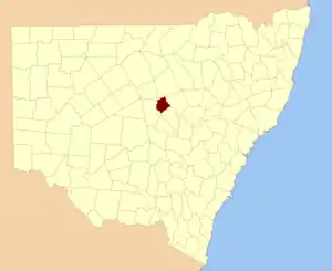
Oxley
New South Wales
Location in New South Wales
Lands administrative divisions around Oxley:
Canbelego Gregory Gregory
Flinders Oxley Ewenmar
Flinders Kennedy Narromine

Oxley County, New South Wales is one of the 141 Cadastral divisions of New South Wales. It is located between the Bogan River on the west, and the Macquarie River on the east. This is the area approximately between Warren and Nyngan.

Oxley County was named in honour of Surveyor-General and explorer John Joseph William Molesworth Oxley (1785-1828).[1]

Parishes within this county

A full list of parishes found within this county; their current LGA and mapping coordinates to the approximate centre of each location is as follows:

ParishLGACoordinates
BalcombeWarren Shire31°59′54″S 147°30′04″E / 31.99833°S 147.50111°E / -31.99833; 147.50111 (Balcombe)
BeablebarWarren Shire31°47′54″S 147°24′04″E / 31.79833°S 147.40111°E / -31.79833; 147.40111 (Beablebar)
BeardinaWarren Shire31°27′54″S 147°38′04″E / 31.46500°S 147.63444°E / -31.46500; 147.63444 (Beardina)
BeelbanWarren Shire31°49′54″S 147°36′04″E / 31.83167°S 147.60111°E / -31.83167; 147.60111 (Beelban)
BeleringarWarren Shire31°34′54″S 147°36′04″E / 31.58167°S 147.60111°E / -31.58167; 147.60111 (Beleringar)
BoroWarren Shire31°59′54″S 147°37′04″E / 31.99833°S 147.61778°E / -31.99833; 147.61778 (Boro)
BuddabadahBogan Shire31°53′54″S 147°14′04″E / 31.89833°S 147.23444°E / -31.89833; 147.23444 (Buddabadah)
CajildryWarren Shire32°14′54″S 147°18′04″E / 32.24833°S 147.30111°E / -32.24833; 147.30111 (Cajildry)
CarualWarren Shire31°37′54″S 147°44′04″E / 31.63167°S 147.73444°E / -31.63167; 147.73444 (Carual)
CookandoonBogan Shire31°35′54″S 147°24′04″E / 31.59833°S 147.40111°E / -31.59833; 147.40111 (Cookandoon)
CremorneWarren Shire31°53′54″S 147°26′04″E / 31.89833°S 147.43444°E / -31.89833; 147.43444 (Cremorne)
CurtisWarren Shire32°02′54″S 147°34′04″E / 32.04833°S 147.56778°E / -32.04833; 147.56778 (Curtis)
DaroubleBogan Shire31°41′54″S 147°14′04″E / 31.69833°S 147.23444°E / -31.69833; 147.23444 (Darouble)
DooranWarren Shire31°33′54″S 147°38′04″E / 31.56500°S 147.63444°E / -31.56500; 147.63444 (Dooran)
EgelabraWarren Shire31°47′54″S 147°50′04″E / 31.79833°S 147.83444°E / -31.79833; 147.83444 (Egelabra)
EilginbahWarren Shire31°43′54″S 147°38′04″E / 31.73167°S 147.63444°E / -31.73167; 147.63444 (Eilginbah)
ElengerahWarren Shire31°51′54″S 147°54′04″E / 31.86500°S 147.90111°E / -31.86500; 147.90111 (Elengerah)
GanalgangWarren Shire31°49′54″S 147°56′04″E / 31.83167°S 147.93444°E / -31.83167; 147.93444 (Ganalgang)
GarfieldWarren Shire31°53′54″S 147°32′04″E / 31.89833°S 147.53444°E / -31.89833; 147.53444 (Garfield)
GaruleWarren Shire31°49′54″S 147°04′04″E / 31.83167°S 147.06778°E / -31.83167; 147.06778 (Garule)
GunningbaWarren Shire31°39′54″S 147°40′04″E / 31.66500°S 147.66778°E / -31.66500; 147.66778 (Gunningba)
KungerbilBogan Shire31°35′54″S 147°18′04″E / 31.59833°S 147.30111°E / -31.59833; 147.30111 (Kungerbil)
LawsonWarren Shire31°43′54″S 147°46′04″E / 31.73167°S 147.76778°E / -31.73167; 147.76778 (Lawson)
MudallBogan Shire31°51′54″S 147°12′04″E / 31.86500°S 147.20111°E / -31.86500; 147.20111 (Mudall)
Mulla MullaBogan Shire31°45′54″S 147°20′04″E / 31.76500°S 147.33444°E / -31.76500; 147.33444 (Mulla Mulla)
MullengudgeryWarren Shire31°35′54″S 147°28′04″E / 31.59833°S 147.46778°E / -31.59833; 147.46778 (Mullengudgery)
MumbrabahWarren Shire31°43′54″S 147°26′04″E / 31.73167°S 147.43444°E / -31.73167; 147.43444 (Mumbrabah)
MungeribarBogan Shire31°39′54″S 147°22′04″E / 31.66500°S 147.36778°E / -31.66500; 147.36778 (Mungeribar)
NarrarWarren Shire31°27′54″S 147°32′04″E / 31.46500°S 147.53444°E / -31.46500; 147.53444 (Narrar)
NarromineWarren Shire31°51′54″S 147°50′04″E / 31.86500°S 147.83444°E / -31.86500; 147.83444 (Narromine)
NevertireWarren Shire31°59′54″S 147°41′04″E / 31.99833°S 147.68444°E / -31.99833; 147.68444 (Nevertire)
NynganBogan Shire31°35′54″S 147°12′04″E / 31.59833°S 147.20111°E / -31.59833; 147.20111 (Nyngan)
RubyBogan Shire31°51′54″S 147°18′04″E / 31.86500°S 147.30111°E / -31.86500; 147.30111 (Ruby)
RutledgeBogan Shire31°51′54″S 147°24′04″E / 31.86500°S 147.40111°E / -31.86500; 147.40111 (Rutledge)
TabratongWarren Shire32°06′54″S 147°31′04″E / 32.11500°S 147.51778°E / -32.11500; 147.51778 (Tabratong)
TeranganWarren Shire32°00′54″S 147°26′04″E / 32.01500°S 147.43444°E / -32.01500; 147.43444 (Terangan)
TeroobleWarren Shire31°33′54″S 147°32′04″E / 31.56500°S 147.53444°E / -31.56500; 147.53444 (Terooble)
The PlainsBogan Shire31°47′54″S 147°10′04″E / 31.79833°S 147.16778°E / -31.79833; 147.16778 (The Plains)
TrowanWarren Shire31°45′54″S 147°28′04″E / 31.76500°S 147.46778°E / -31.76500; 147.46778 (Trowan)
WarienWarren Shire31°39′54″S 147°28′04″E / 31.66500°S 147.46778°E / -31.66500; 147.46778 (Warien)
WarrenWarren Shire31°39′54″S 147°46′04″E / 31.66500°S 147.76778°E / -31.66500; 147.76778 (Warren)
WeraBogan Shire31°43′54″S 147°14′04″E / 31.73167°S 147.23444°E / -31.73167; 147.23444 (Wera)
WoolarthaWarren Shire31°39′54″S 147°34′04″E / 31.66500°S 147.56778°E / -31.66500; 147.56778 (Woolartha)

References

  1. "Oxley County". Geographical Names Register (GNR) of NSW. Geographical Names Board of New South Wales.
This article is issued from Wikipedia. The text is licensed under Creative Commons - Attribution - Sharealike. Additional terms may apply for the media files.