| Boundary Peak | |
|---|---|
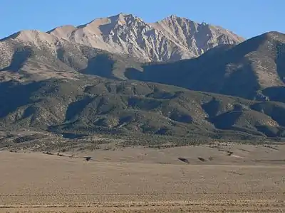
 Boundary Peak as seen from Benton. Boundary is on the left (east), while connecting to higher Montgomery Peak on the right (west). | |
| Highest point | |
| Elevation | 13,147 ft (4,007 m) NAVD 88[1] |
| Prominence | 253 ft (77 m)[2] |
| Listing |
|
| Coordinates | 37°50′46″N 118°21′05″W / 37.846097728°N 118.351299017°W[1] |
| Geography | |
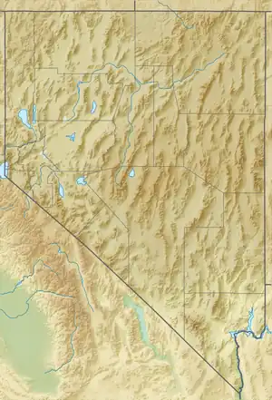
 Boundary Peak | |
| Parent range | White Mountains |
| Topo map | USGS Boundary Peak |
| Geology | |
| Age of rock | Cretaceous |
| Mountain type | Quartz monzonite |
| Climbing | |
| Easiest route | Scramble, class 2[3] |
Boundary Peak is a mountain in Esmeralda County, Nevada, United States. With a peak elevation of 13,147 feet (4,007 m), it is the highest natural point in the state of Nevada.[2]
Geography
Boundary Peak is the northernmost peak of 13,000 feet or greater elevation within the White Mountains. The summit is located in Esmeralda County of southwestern Nevada, and is within the Boundary Peak Wilderness of the Inyo National Forest. It is less than half a mile (1 km) from the California state line, which is how it derived its name.[4]
While it is the highest point in Nevada, the considerably taller Montgomery Peak (13,441 feet or 4,097 metres) is less than 1 mi (1.6 km) away, across the state line in California. By most definitions Boundary Peak, which has a prominence of only 253 ft (77 m), is considered to be a sub-peak of Montgomery Peak.
Boundary Peak is only 82 feet (25 m) taller than Wheeler Peak, which is located in Great Basin National Park, White Pine County in eastern Nevada. By most definitions, Wheeler Peak is the tallest independent mountain within Nevada.
Climate
| Climate data for Boundary Peak 37.8358 N, 118.3558 W, Elevation: 12,651 ft (3,856 m) (1991–2020 normals) | |||||||||||||
|---|---|---|---|---|---|---|---|---|---|---|---|---|---|
| Month | Jan | Feb | Mar | Apr | May | Jun | Jul | Aug | Sep | Oct | Nov | Dec | Year |
| Mean daily maximum °F (°C) | 26.6 (−3.0) |
23.8 (−4.6) |
27.2 (−2.7) |
30.9 (−0.6) |
39.0 (3.9) |
51.6 (10.9) |
59.4 (15.2) |
58.5 (14.7) |
50.5 (10.3) |
41.4 (5.2) |
33.0 (0.6) |
25.6 (−3.6) |
39.0 (3.9) |
| Daily mean °F (°C) | 17.8 (−7.9) |
15.3 (−9.3) |
18.1 (−7.7) |
21.3 (−5.9) |
27.6 (−2.4) |
38.2 (3.4) |
45.3 (7.4) |
44.4 (6.9) |
39.7 (4.3) |
31.8 (−0.1) |
24.0 (−4.4) |
17.5 (−8.1) |
28.4 (−2.0) |
| Mean daily minimum °F (°C) | 9.1 (−12.7) |
6.7 (−14.1) |
9.1 (−12.7) |
11.7 (−11.3) |
16.3 (−8.7) |
24.8 (−4.0) |
31.1 (−0.5) |
30.2 (−1.0) |
28.9 (−1.7) |
22.2 (−5.4) |
15.1 (−9.4) |
9.4 (−12.6) |
17.9 (−7.8) |
| Average precipitation inches (mm) | 1.81 (46) |
2.34 (59) |
2.48 (63) |
1.49 (38) |
1.90 (48) |
0.62 (16) |
0.93 (24) |
0.96 (24) |
0.46 (12) |
1.12 (28) |
0.72 (18) |
2.26 (57) |
17.09 (433) |
| Source: PRISM Climate Group[5] | |||||||||||||
Climbing
This peak is most often climbed from the Nevada side. From there, a climber may scramble the ridge connecting to Montgomery Peak. It is recommended that the U.S. Forest Service (Inyo National Forest) be contacted so they can provide climbing information.

See also
References
- 1 2 "Boundary". NGS Data Sheet. National Geodetic Survey, National Oceanic and Atmospheric Administration, United States Department of Commerce. Retrieved 2008-04-03.
- 1 2 "Boundary Peak, Nevada". Peakbagger.com. Retrieved 2008-04-03.
- 1 2 "Desert Peaks Section List" (PDF). Angeles Chapter, Sierra Club.
- ↑ Federal Writers' Project (1941). Origin of Place Names: Nevada (PDF). W.P.A. p. 31.
- ↑ "PRISM Climate Group, Oregon State University". PRISM Climate Group, Oregon State University. Retrieved September 30, 2023.
To find the table data on the PRISM website, start by clicking Coordinates (under Location); copy Latitude and Longitude figures from top of table; click Zoom to location; click Precipitation, Minimum temp, Mean temp, Maximum temp; click 30-year normals, 1991-2020; click 800m; click Retrieve Time Series button.
External links
- "Boundary Peak". Geographic Names Information System. United States Geological Survey, United States Department of the Interior. Retrieved 2008-11-21.
- Inyo National Forest: Boundary Peak Wilderness Area.