| Bumbobi–Bubulo–Lwakhakha Road | |
|---|---|
| Route information | |
| Length | 28 mi (45 km) |
| History | Designation in 2016 Completion in 2020 |
| Major junctions | |
| West end | Bumbobi |
| Nabumali | |
| East end | Lwakhakha |
| Location | |
| Country | Uganda |
| Highway system | |
Bumbobi–Bubulo–Lwakhakha Road is a road in the Eastern Region of Uganda, connecting the city of Mbale to the town of Lwakhakha at the International border with Kenya.[1]
Location
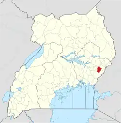
The road starts at Bumbobi, a suburb of the city of Mbale (2014 population: 92,857), the most populous city in Uganda's Eastern Region.[2] The road continues through Nabumali and Bubulo to end at Lwakhakha, a total distance of about 46 kilometres (29 mi).[3] The road connects Manafwa District to Mbale, the largest city in the Bugisu sub-region. The coordinates of the road near Bubulo are 0°57'03.0"N, 34°16'17.0"E (Latitude:0.950833; Longitude:34.271389).[4]
Upgrading to bitumen
The government of Uganda requested funding from the African Development Bank (ADB) to upgrade this road from gravel surface to class 2 bitumen surface. As required by Ugandan law and ADB guidelines, an environment assessment study was commissioned and its report published in 2013.[5] Construction was expected to start once funding was approved and a contractor was selected and hired. As of November 2014, project preparation was ongoing.[6]
Construction
The construction contract was awarded to China State Construction Engineering Corporation (CSCEC), at a contract price of UGX:153.105 billion (approx. US$42 million). The engineering consultant was SGI Joint Venture. The civil works contract was signed on 26 September 2016. Permission to start work was granted in December 2016. Expected completion was in August 2019. Te project was jointly funded by the African Development Bank and the government of Uganda.[7] As of July 2020, completion was anticipated in September 2020.[8] In December 2020, the completed road was commissioned by Yoweri Museveni, the president of Uganda at that time.[9]
See also
References
- ↑ Shem Oirere (3 October 2014). "Two New Road Links Will Help Boost Uganda's Economy". Dartford, United Kingdom: Worldhighways.com. Retrieved 11 September 2020.
- ↑ UBOS (27 August 2014). "The Population of The Regions of the Republic of Uganda And All Cities And Towns of More Than 15,000 Inhabitants". Citypopulation.de Quoting Uganda Bureau of Statistics (UBOS). Retrieved 11 September 2020.
- ↑ Google (11 September 2020). "Distance Between Bumbobi Church of Uganda And Lwakhakha" (Map). Google Maps. Google. Retrieved 11 September 2020.
- ↑ Google (11 September 2020). "Location of Bumbobi–Bubulo–Lwakhakha Road At Google Maps" (Map). Google Maps. Google. Retrieved 11 September 2020.
- ↑ Robert Ndyabarema; et al. (November 2013). "Bumbobi-Bubulo-Lwakhakha Road: Environment And Social Impact Statement (ESIS) - Updated Final Report November 2013" (PDF). African Development Bank. Retrieved 11 September 2020.
- ↑ Sunrise Uganda (4 November 2014). "UNRA to begin works on 16 roads next year". Kampala: Sunrise.ug. Retrieved 11 September 2020.
- ↑ Uganda National Roads Authority (27 June 2019). "Project Profile: Bumbobi – Lwakhakha (44.5 km)". Kampala: Uganda National Roads Authority. Retrieved 11 September 2020.
- ↑ David Mafabi (31 July 2020). "Bumbobi-Lwakhakha road works stand at 92% completion, UNRA". Kampala: PML Daily. Retrieved 11 September 2020.
- ↑ New Vision (1 December 2020). "President Museveni commissions Bumbobi-Lwakhakha Road". New Vision. Kampala. Retrieved 3 December 2020.

