Caieiras | |
|---|---|
 | |
 Flag  Coat of arms | |
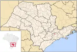
 Location of Caieiras | |
 Caieiras Location of Caieiras | |
| Coordinates: 23°21′52″S 46°44′27″W / 23.36444°S 46.74083°W | |
| Country | |
| Region | Southeast |
| State | |
| Metropolitan Region | São Paulo |
| Government | |
| • Prefect | Gerson Romeiro |
| Area | |
| • Total | 97.64 km2 (37.70 sq mi) |
| Population (2020 [1]) | |
| • Total | 102,775 |
| • Density | 1,100/km2 (2,700/sq mi) |
| Demonym | Caieirense |
| Time zone | UTC−3 (BRT) |
Caieiras is a municipality in the state of São Paulo in Brazil.[2] It is part of the Metropolitan Region of São Paulo.[3] The population is 102,775 (2020 est.) in an area of 97.64 km².[4] Due to the municipality's large reforestation area, it is known as the "City of the Pines".
The municipality contains part of the 7,917 hectares (19,560 acres) Cantareira State Park, created in 1962, which protects a large part of the metropolitan São Paulo water supply.[5]
The municipality is served by CPTM Line 7 (Ruby).
Economy
The economy of the city is based on paper industry. Most of the territory of the town consists of reforesting areas belonging to Companhia Melhoramentos de São Paulo.
References
- ↑ IBGE 2020
- ↑ "Prefeitura Municipal de Caieiras (Portuguese)". Archived from the original on 2011-05-01. Retrieved 2011-01-25.
- ↑ "Lei Complementar nº 1.139, de 16 de junho de 2011". Archived from the original on 2015-10-01. Retrieved 2015-09-30.
- ↑ "Brazilian Institute of Geography and Statistics" (PDF). 2018. Retrieved 6 March 2019.
2018 Estimates of Population
- ↑ Leonel, Cristiane (June 2009), Plano de Manejo do Parque Estadual da Cantareira: Resumo Executivo (PDF) (in Portuguese), SEMA/SP, p. vi, retrieved 2016-12-10
External links
![]() Media related to Caieiras at Wikimedia Commons
Media related to Caieiras at Wikimedia Commons
This article is issued from Wikipedia. The text is licensed under Creative Commons - Attribution - Sharealike. Additional terms may apply for the media files.