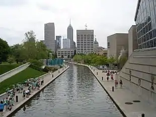
Center Township Marion County | |
|---|---|
 Downtown Indianapolis | |
 Location in Marion County | |
| Coordinates: 39°46′25″N 86°08′22″W / 39.77361°N 86.13944°W | |
| Country | United States |
| State | Indiana |
| County | Marion |
| Government | |
| • Type | Indiana township |
| • Trustee | Eugene A. Akers |
| Area | |
| • Total | 42.7 sq mi (111 km2) |
| • Land | 41.85 sq mi (108.4 km2) |
| • Water | 0.84 sq mi (2.2 km2) 1.97% |
| Elevation | 715 ft (218 m) |
| Population (2010) | |
| • Total | 142,787 |
| • Density | 3,411.6/sq mi (1,317.2/km2) |
| ZIP codes | 46107, 46201, 46202, 46203, 46204, 46205, 46208, 46217, 46218, 46219, 46221, 46222, 46225, 46237 |
| GNIS feature ID | 0453186 |
| Website | http://centergov.org/ |
Center Township is one of nine townships in Marion County, Indiana, in the United States. As of the 2010 census, its population was 142,787 and it contained 76,872 housing units.[1] It is the most populated township in Marion County.
Center Township includes downtown Indianapolis and part of Beech Grove.
Geography
| Census | Pop. | Note | %± |
|---|---|---|---|
| 1890 | 117,328 | — | |
| 1900 | 167,970 | 43.2% | |
| 1910 | 218,497 | 30.1% | |
| 1920 | 283,414 | 29.7% | |
| 1930 | 300,073 | 5.9% | |
| 1940 | 314,505 | 4.8% | |
| 1950 | 337,211 | 7.2% | |
| 1960 | 333,351 | −1.1% | |
| 1970 | 273,634 | −17.9% | |
| 1980 | 208,624 | −23.8% | |
| 1990 | 182,140 | −12.7% | |
| 2000 | 167,055 | −8.3% | |
| 2010 | 142,787 | −14.5% | |
| 2020 | 153,549 | 7.5% | |
| 2021 (est.) | 152,629 | −0.6% |
According to the 2010 census, the township has a total area of 42.7 square miles (111 km2), of which 41.85 square miles (108.4 km2) (or 98.01%) is land and 0.84 square miles (2.2 km2) (or 1.97%) is water.[1]
Municipalities
- Beech Grove (northern quarter)
- Indianapolis (partial)
Communities
- Belmont at 39°45′08″N 86°11′42″W / 39.752266°N 86.194988°W
- Clifton at 39°48′58″N 86°10′59″W / 39.816153°N 86.183044°W
- Fountain Square
- Ingallston at 39°43′30″N 86°05′05″W / 39.725044°N 86.084707°W
- Martindale-Brightwood
- North Indianapolis at 39°48′28″N 86°10′41″W / 39.807820°N 86.178043°W
- Riverside
- South Village
- Woodruff Place at 39°46′39″N 86°07′42″W / 39.777543°N 86.128319°W
Extinct communities
- Babe Denny at 39°45′20″N 86°09′53″W / 39.755481°N 86.164663°W
- Brightwood at 39°48′13″N 86°06′35″W / 39.803653°N 86.109708°W
- Clifford Park at 39°47′20″N 86°05′17″W / 39.788931°N 86.088041°W
(These towns are listed as "historical" by the USGS.)
Cemeteries
The township contains five notable cemeteries: Concordia, Crown Hill, Hebrew, Holy Cross and Saint Joseph, and New Crown.
Major highways
Airports and landing strips
- ISHC Landing Pad
- Indiana Department of Natural Resources Airport
- Indianapolis Downtown Heliport
- Methodist Hospital Helistop
Lakes
- Sullivan Lake
Notable people
- Donie Bush, longtime Major League Baseball player, manager, and scout.
- Wilbur D'Alene, racing driver
- Julia Carson, former U.S. Representative and onetime Center Township Trustee.
- André Carson, current Representative for Indiana's 7th Congressional District, grandson of Julia Carson.
School districts
Political districts
- Indiana's 7th congressional district
- State House District 100
- State House District 86
- State House District 96
- State House District 97
- State House District 98
- State House District 99
- State Senate District 31
- State Senate District 32
- State Senate District 33
- State Senate District 34
- State Senate District 35
- State Senate District 36
See also
References
- "Center Township, Marion County, Indiana". Geographic Names Information System. United States Geological Survey, United States Department of the Interior. Retrieved September 29, 2009.
- United States Census Bureau 2008 TIGER/Line Shapefiles
- IndianaMap
- 1 2 "Population, Housing Units, Area, and Density: 2010 - County -- County Subdivision and Place -- 2010 Census Summary File 1". United States Census. Archived from the original on February 12, 2020. Retrieved May 10, 2013.
External links
This article is issued from Wikipedia. The text is licensed under Creative Commons - Attribution - Sharealike. Additional terms may apply for the media files.