Cheb District
Okres Cheb | |
|---|---|
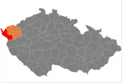
 Location in the Karlovy Vary Region within the Czech Republic | |
 | |
| Coordinates: 50°3′N 12°27′E / 50.050°N 12.450°E | |
| Country | |
| Region | Karlovy Vary |
| Capital | Cheb |
| Area | |
| • Total | 1,045.91 km2 (403.83 sq mi) |
| Population (2023)[2] | |
| • Total | 92,636 |
| • Density | 89/km2 (230/sq mi) |
| Time zone | UTC+1 (CET) |
| • Summer (DST) | UTC+2 (CEST) |
| Municipalities | 40 |
| * Towns | 10 |
| * Market towns | 0 |
Cheb District (Czech: okres Cheb) is a district in the Karlovy Vary Region of the Czech Republic. Its capital is the town of Cheb. It is the westernmost district of the Czech Republic.
Administrative division
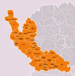
Cheb District is divided into three administrative districts of municipalities with extended competence: Cheb, Aš and Mariánské Lázně.
List of municipalities
Towns are marked in bold:
Aš - Cheb - Dolní Žandov - Drmoul - Františkovy Lázně - Hazlov - Hranice - Krásná - Křižovatka - Lázně Kynžvart - Libá - Lipová - Luby - Mariánské Lázně - Milhostov - Milíkov - Mnichov - Nebanice - Nový Kostel - Odrava - Okrouhlá - Ovesné Kladruby - Plesná - Podhradí - Pomezí nad Ohří - Poustka - Prameny - Skalná - Stará Voda - Teplá - Třebeň - Tři Sekery - Trstěnice - Tuřany - Valy - Velká Hleďsebe - Velký Luh - Vlkovice - Vojtanov - Zádub-Závišín
Geography
.JPG.webp)
Cheb District borders Germany in the west. It includes the Aš Panhandle area, which makes it the westernmost district of the Czech Republic. The relief is very varied and includes both flat plains and hilly areas with relatively high altitudes. The territory extends into seven geomorphological mesoregions: Cheb Basin (centre), Fichtel Mountains (west), Upper Palatine Forest (southwest), Upper Palatine Forest Foothills (south), Teplá Highlands (east), Slavkov Forest (northeast) and Ore Mountains (small part in the north). The highest point of the district is the mountain Lesný in Dolní Žandov with an elevation of 983 m (3,225 ft). The lowest point is the river bed of the Ohře in Odrava at 415 m (1,362 ft).
From the total district area of 1,045.9 km2 (403.8 sq mi), agricultural land occupies 501.7 km2 (193.7 sq mi), forests occupy 409.9 km2 (158.3 sq mi), and water area occupies 32.3 km2 (12.5 sq mi). Forests cover 39.2% of the district's area.[1]
The most important river is the Ohře, which flows across the district from west to east. Its longest tributary in the area are the rivers Plesná and Teplá. The rivers White Elster and Wondreb spring here and head to Germany. The Röslau briefly forms the Czech-German border before its confluence with the Ohře. The largest bodies of water are two reservoirs: Jesenice, built on the Wondreb, and Skalka, built on the Ohře.
There is one protected landscape area, located in the east of the district: Slavkovský les.
Demographics
|
|
| ||||||||||||||||||||||||||||||||||||||||||||||||||||||
| Source: Censuses[3][4] | ||||||||||||||||||||||||||||||||||||||||||||||||||||||||
Most populated municipalities
| Name | Population[2] | Area (km2) |
|---|---|---|
| Cheb | 31,954 | 96 |
| Mariánské Lázně | 13,766 | 52 |
| Aš | 12,804 | 56 |
| Františkovy Lázně | 5,707 | 26 |
| Teplá | 2,926 | 113 |
| Velká Hleďsebe | 2,343 | 5 |
| Luby | 2,194 | 31 |
| Hranice | 2,087 | 32 |
| Plesná | 1,917 | 19 |
| Skalná | 1,916 | 23 |
Economy
The largest employers with headquarters in Cheb District and at least 500 employees are:[5]
| Economic entity | Location | Number of employees | Main activity |
|---|---|---|---|
| Elektrometall | Mariánské Lázně | 500–999 | Automotive industry |
| Léčebné lázně Mariánské Lázně | Mariánské Lázně | 500–999 | Health care |
Transport
The D6 motorway from Prague to Karlovy Vary and Cheb (part of the European routes E48 and E49) forks and continues to the Czech-German border to the west (as E48) and to the north (as E49).
Sights

The town centres of Mariánské Lázně and Františkovy Lázně with the spa cultural landscapes were designated a UNESCO World Heritage Site in 2021 as part of the transnational Great Spa Towns of Europe because of its springs and architectural testimony to the popularity of spa towns in Europe during the 18th through 20th centuries.[6]
The most important monuments in the district, protected as national cultural monuments, are:[7]
- Kynžvart Castle
- Kynžvart Daguerreotype
- Teplá Abbey
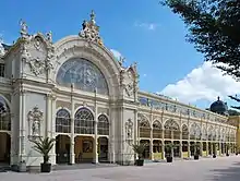
- Spa colonnade in Mariánské Lázně
- Artificial water channel Dlouhá stoka (partly)
- Cheb Castle
The best-preserved settlements and landscapes, protected as monument reservations and monument zones, are:[8]
- Cheb (monument reservation)
- Františkovy Lázně (monument reservation)
- Mariánské Lázně (monument reservation)
- Doubrava (monument reservation)
- Nový Drahov (monument reservation)
- Teplá
- Beranov
- Dolní Lažany
- Popovice
- Salajna
- Landscape around Kladská
The most visited tourist destinations are the Boheminium miniature park in Mariánské Lázně, Soos national nature reserve in Skalná, Cheb Castle, and Kynžvart Castle.[9]
Notable people
References
- 1 2 "Land use (as at 31 December)". Public database. Czech Statistical Office. Retrieved 2023-05-17.
- 1 2 "Population of Municipalities – 1 January 2023". Czech Statistical Office. 2023-05-23.
- ↑ "Historický lexikon obcí České republiky 1869–2011 – Okres Cheb" (in Czech). Czech Statistical Office. 2015-12-21. pp. 1–2.
- ↑ "Population Census 2021: Population by sex". Public Database. Czech Statistical Office. 2021-03-27.
- ↑ "Registr ekonomických subjektů". Business Register (in Czech). Czech Statistical Office. Retrieved 2023-02-21.
- ↑ "The Great Spa Towns of Europe". UNESCO. Retrieved 2023-02-21.
- ↑ "Výsledky vyhledávání: Národní kulturní památky, okres Cheb". Ústřední seznam kulturních památek (in Czech). National Heritage Institute. Retrieved 2023-02-21.
- ↑ "Výsledky vyhledávání: Památkové rezervace, Památkové zóny, okres Cheb". Ústřední seznam kulturních památek (in Czech). National Heritage Institute. Retrieved 2023-02-21.
- ↑ "Turisté mají v České republice nejraději zoologické zahrady, technické památky, koupání a Pražský hrad" (in Czech). CzechTourism. 2022-06-24. Retrieved 2023-02-21.
External links
- Cheb District – profile on the Czech Statistical Office website