.svg.png.webp) | ||||
|---|---|---|---|---|
| 315国道 | ||||
 | ||||
| Route information | ||||
| Length | 3,063 km (1,903 mi) | |||
| Major junctions | ||||
| From | Xining, Qinghai | |||
| To | Kashi, Xinjiang | |||
| Location | ||||
| Country | China | |||
| Highway system | ||||
| ||||
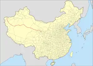
Constructed in 1954, the Qinghai-Xinjiang Highway, also known as the China National Highway 315 (G315) runs west from Xining, Qinghai towards Kashgar, Xinjiang. It is 3,063 kilometres (1,903 mi) in length. In 1994 the departments of communication and transportation in Qinghai and Xinjiang began the process of updating the highway.[1][2] In the west it follows the desert Qaidam Basin south of the traditional Silk Road, crosses the Altyn-Tagh into Xinjiang, and then follows the south side of the Tarim Basin to Kashgar.
Route and distance
| Route and distance | ||||||||||||||||||||||||||||||||||||||||||||||
|
Gallery
Hotan Prefecture (Mingfeng-Hotan-Pishan), Xinjiang
 Cruising pleasantly along the tree-lined highway
 After heavy rain, the highway was closed for three days (June, 2013)
Kashgar Prefecture (Yarkand-Yengisar-Kashgar), Xinjiang
See also
References
- ↑ United States; Foreign Broadcast Information Service (8 April 1994). "The Daily Report: China" (Microfiche). No. 68. National Technical Information Service. Foreign Broadcast Information Service. pp. 49–50.
Built in 1954, the 2,728-kilometer highway starts from Xining City, capital of the Qinghai Province, and runs to Shache [as received] in the Xinjiang Uygur Autonomous Region.
{{cite news}}: CS1 maint: multiple names: authors list (link) - ↑ 国家干线公路查询表 Archived 2011-07-07 at the Wayback Machine(in Chinese)
External links
Wikimedia Commons has media related to China National Highway 315.
This article is issued from Wikipedia. The text is licensed under Creative Commons - Attribution - Sharealike. Additional terms may apply for the media files.


