Chowplu
Persian: چوپلو | |
|---|---|
Village | |
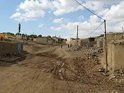 The village of Chowplu | |
 Chowplu | |
| Coordinates: 36°30′47″N 46°57′13″E / 36.51306°N 46.95361°E[1] | |
| Country | |
| Province | West Azerbaijan |
| County | Takab |
| District | Takht-e Soleyman |
| Rural District | Saruq |
| Population (2016)[2] | |
| • Total | 1,788 |
| Time zone | UTC+3:30 (IRST) |
Chowplu (Persian: چوپلو, also Romanized as Chowplū; also known as Choplī and Choplū)[3] is a village in Saruq Rural District of Takht-e Soleyman District of Takab County, West Azerbaijan province, Iran.
At the 2006 National Census, its population was 1,871 in 368 households.[4] The following census in 2011 counted 1,958 people in 480 households.[5] The latest census in 2016 showed a population of 1,788 people in 492 households; it was the largest village in its rural district.[2]
References
- ↑ OpenStreetMap contributors (10 March 2023). "Chowplu, Takab County" (Map). OpenStreetMap. Retrieved 10 March 2023.
- 1 2 "Census of the Islamic Republic of Iran, 1395 (2016)". AMAR (in Persian). The Statistical Center of Iran. p. 04. Archived from the original (Excel) on 30 August 2022. Retrieved 19 December 2022.
- ↑ Chowplu can be found at GEOnet Names Server, at this link, by opening the Advanced Search box, entering "-3058836" in the "Unique Feature Id" form, and clicking on "Search Database".
- ↑ "Census of the Islamic Republic of Iran, 1385 (2006)". AMAR (in Persian). The Statistical Center of Iran. p. 04. Archived from the original (Excel) on 20 September 2011. Retrieved 25 September 2022.
- ↑ "Census of the Islamic Republic of Iran, 1390 (2011)". Syracuse University (in Persian). The Statistical Center of Iran. p. 04. Archived from the original (Excel) on 20 January 2023. Retrieved 19 December 2022.
West Azerbaijan province, Iran | ||
|---|---|---|
| Capital | 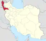 | |
| Counties and cities | ||
| Tourism | ||
| Places | ||
This article is issued from Wikipedia. The text is licensed under Creative Commons - Attribution - Sharealike. Additional terms may apply for the media files.