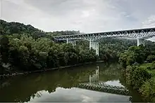
The Clay's Ferry Bridge is a combination of three former bridges combined into one bridge. It carries Interstate 75 along with US 25 and US 421 across the Kentucky River between Madison and Fayette counties.[1]

History
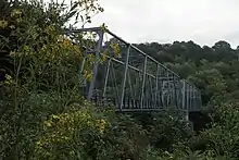
The Clay's Ferry Bridge replaced an older road bridge of the same name in 1946. Now called the Old Clay's Ferry Bridge is a series of two Warren truss structures constructed in 1869. After the State of Kentucky purchased it, the bridge was made part of the alignment of US 25 in 1929.[1][2] Prior to 1869, service across the Kentucky River was provided by ferry.[3]

The first high-level bridge across the Kentucky River was completed in 1946, carrying two lanes of traffic (one northbound, one southbound).[5] It was 280 feet (85 m) above the river level and was the tallest bridge east of the Mississippi after completion,[6] with a total length of 1,736 feet (529 m).[3] In 1963, a twin bridge was completed just south of the existing bridge and traffic ran in two lanes in each direction, with each span made one-way.[7] After over two decades of use, a Fatigue Analysis of the Clays Ferry Bridge was completed. This was conducted in 1988 by Theodore Hopwood II, and Vishwas G. Oka, from the Kentucky Transportation Center Research, Report 539.
Plans were announced in 1989 to demolish the 1946 and 1963 bridges, except for their piers, and build a replacement using the old piers plus new ones. The new bridge was completed in 1998, creating three lanes in each direction and full-width shoulders. Each northbound/southbound roadway is 60 feet (18 m) wide, and total traffic over the bridge was 75,000 vehicles per day in 2015.[5][8] The old one lane Warren truss bridge, now called the Old Clay's Ferry Bridge is still in use.
The most recent resurface project of the Clays Ferry Bridge began on Aug 1, 2021 and was projected to be completed by oct 27 2021. It was completed ahead of schedule on Oct 11, 2021.[9]

References
- 1 2 "Old Clays Ferry Bridge - HistoricBridges.org". historicbridges.org. Retrieved 2021-11-30.
- ↑ "Clays Ferry Bridge (KY 2328)". bridges and tunnels.com. Retrieved 6 September 2018.
- 1 2 "New Clays Ferry bridge nears completion, 1946". Kentucky Photo Archive. 29 July 2018. Retrieved 6 September 2018.
- ↑ 78pa107: [identification of item], High Bridge Photograph Collection, 1876-1877, undated, University of Kentucky Special Collections Research Center.
- 1 2 "I-75 Clays Ferry bridges". Kentucky Photo Archive. March 6, 2017. Retrieved 6 September 2018.
- ↑ "Clays Ferry bridge, 1944". Kentucky Photo Archive. July 2, 2014. Retrieved 6 September 2018.
- ↑ Hopewood, Theodore II (1988). "Fatigue Analysis of the I-75 Bridge over the Kentucky River at Clays Ferry". Kentucky Transportation Center Research Report. 539: All.
- ↑ "Clays Ferry Interstate Bridge". Bridges and Tunnels. Retrieved 2021-11-30.
- ↑ "Update - Bridge deck overlay project for the Clays Ferry Bridge". Kentucky Transportation Cabinet. Retrieved 2021-12-01.
External links
- "Clay's Ferry Bridge: Fayette County, Kentucky, and Madison County, Kentucky". Bridgehunter. Retrieved 6 September 2018.
37°53′02″N 84°20′21″W / 37.8838°N 84.3393°W