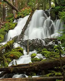
The Clearwater River is a river in Douglas County of the U.S. state of Oregon.[1] It is a roughly 15-mile (24 km) long tributary of the North Umpqua River, located about 50 miles (80 km) east of Roseburg in the Cascade Range.
There are two notable waterfalls along the river. Upstream is Clearwater Falls, and downstream a few miles is Whitehorse Falls, the smaller of the two.

Clearwater Falls
| coordinate | USGS map |
|---|---|
| 43°15′46″N 122°25′07″W / 43.2629°N 122.418653°W | Toketee Falls |
| 43°14′58″N 122°23′37″W / 43.249567°N 122.393652°W | Fish Creek Desert |
| 43°14′30″N 122°22′32″W / 43.241789°N 122.375596°W | Garwood Butte |
| 43°14′59″N 122°13′37″W / 43.249847°N 122.22698°W | Lemolo Lake |
| 43°11′23″N 122°12′15″W / 43.189848°N 122.204200°W | Diamond Lake |
See also
References
External links
- Clearwater Falls: Northwest Waterfall Survey
- Whitehorse Falls: Northwest Waterfall Survey
This article is issued from Wikipedia. The text is licensed under Creative Commons - Attribution - Sharealike. Additional terms may apply for the media files.