Cooper Developmental Road | |
|---|---|
 | |
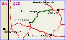
| Cooper Developmental Road (green on black) | |
| General information | |
| Type | Rural road |
| Length | 186 km (116 mi) |
| Major junctions | |
| East end | Diamantina Developmental Road, 37km west of Quilpie, Queensland |
| West end | Bulloo Developmental Road, Durham, Queensland |
| Location(s) | |
| Major settlements | Eromanga |
The Cooper Developmental Road is an outback road in Queensland, Australia. It is sometimes called the Cooper's Creek Developmental Road.[1]
It commences at the Diamantina Developmental Road at 26°36′36″S 143°55′20″E / 26.61005°S 143.92223°E / -26.61005; 143.92223 (approximately 37 kilometres (23 mi) west of Quilpie) and travels south-west for 186 kilometres (116 mi) until it reaches the Bulloo Developmental Road at Durham. 27°21′31″S 142°34′19″E / 27.3587°S 142.5719°E / -27.3587; 142.5719.[2]
Major intersections
This road has no major intersections.
References
- ↑ "South-West Road Facts 2010-11" (PDF). Queensland Government. Archived (PDF) from the original on 17 May 2014. Retrieved 17 May 2014.
- 1 2 "Queensland Government - Department of Transport and Main Roads - Maps". Archived from the original on 19 March 2018. Retrieved 9 December 2015.
This article is issued from Wikipedia. The text is licensed under Creative Commons - Attribution - Sharealike. Additional terms may apply for the media files.