Dalola | |
|---|---|
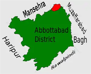 Location of Dalola Union Council (highlighted in red) within Abbottabad district, the names of the neighbouring districts to Abbottabad are also shown. | |
| Coordinates: 34°21′20″N 73°23′50″E / 34.35556°N 73.39722°E | |
| Country | |
| Province | Khyber-Pakhtunkhwa |
| District | Abbottabad |
| Tehsil | Abbottabad[1] |
| Government | |
| • district member | Zaheer abbasi |
| • tehsil member | Abdullah abbasi |
| Population | |
| • Total | 18,900 |
Dalola is one of the 51 union councils (sub-divisions) of Abbottabad District in Khyber-Pakhtunkhwa province of Pakistan.[2]
Location
Dalola is located at 34°21'20N 73°23'50E and has an average elevation of 798 metres (2621 ft).[3] Dalola is the most north-eastern part of the district, it borders U.C Karnol & Garhi Habibullah of Mansehra District to the north and the River Kunhar and Muzaffarabad District of Kashmir to the east. To the south lies U.C Boi and to the west situated Tarnawai (U.C Banda Pir Khan). It was hit quite badly by the 2005 Pakistan earthquake.
Subdivisions
The union council is subdivided into the following areas:
- Malik Ghulam Ali Khan Town
- Awan Abad
- Hoter Awanabad sector 2
- Batangaw Awanabad sector 3
- Gran Awanabad sector 4
- Sehri
- Pindhi
- Kachar
- Kalgran
- Darrah
- Dhora
- Dabban
- Dalola
- Naroka
- Mujffah
- Dogranina
- Sirla / Hadora
- Malkan Gali
- Changli
- choli
- Tarkot
References
- ↑ Dalola Union Council - Abbottabad Government
- ↑ Administrative Units of District Abbottabad Archived April 3, 2007, at the Wayback Machine
- ↑ "Falling Rain Genomics - Location of Dalola". Archived from the original on 2007-10-01. Retrieved 2007-04-18.
This article is issued from Wikipedia. The text is licensed under Creative Commons - Attribution - Sharealike. Additional terms may apply for the media files.