Detvianska Huta | |
|---|---|
Municipality | |
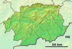 Detvianska Huta Location of Detvianska Huta in the Banská Bystrica Region  Detvianska Huta Detvianska Huta (Slovakia) | |
| Coordinates: 48°34′N 19°36′E / 48.567°N 19.600°E | |
| Country | Slovakia |
| Region | Banská Bystrica |
| District | Detva |
| First mentioned | 1670 |
| Area | |
| • Total | 14.31[1] km2 (5.53[1] sq mi) |
| Elevation | 850[2] m (2,790[2] ft) |
| Population (2021) | |
| • Total | 681[3] |
| Postal code | 962 06[2] |
| Area code | +421 45[2] |
| Car plate | DT |
Detvianska Huta (Mikulášova Huta, 1880 Mikulássowá; Hungarian: Zólyommiklós) is a village and municipality in Detva District, in the Banská Bystrica Region of central Slovakia.
History
It arose in the late 18th century by a merge of villages Komárno and Bratkovica and glasswork settlement (Detvianska Huta literally means "Detva (Glass) Works"). Glassworks stopped its production at the end of 19th century and from 1920 the village bears its present name.
Famous people
- Milan Kolibiar, mathematician
Genealogical resources
The records for genealogical research are available at the state archive "Statny Archiv in Banska Bystrica, Slovakia"
- Roman Catholic church records (births/marriages/deaths): 1763–1934 (parish A)
See also
References
- 1 2 "Hustota obyvateľstva - obce [om7014rr_ukaz: Rozloha (Štvorcový meter)]". www.statistics.sk (in Slovak). Statistical Office of the Slovak Republic. 2022-03-31. Retrieved 2022-03-31.
- 1 2 3 4 "Základná charakteristika". www.statistics.sk (in Slovak). Statistical Office of the Slovak Republic. 2015-04-17. Retrieved 2022-03-31.
- ↑ "Počet obyvateľov podľa pohlavia - obce (ročne)". www.statistics.sk (in Slovak). Statistical Office of the Slovak Republic. 2022-03-31. Retrieved 2022-03-31.
External links
- Official homepage
- http://www.e-obce.sk/obec/detvianskahuta/detvianska-huta.html
- Surnames of living people in Detvianska Huta
Municipalities of Detva District | ||
|---|---|---|
This article is issued from Wikipedia. The text is licensed under Creative Commons - Attribution - Sharealike. Additional terms may apply for the media files.