Downtown Columbia | |
|---|---|
 | |
 Downtown Columbia  Downtown Columbia | |
| Coordinates: 34°0′2″N 81°2′5″W / 34.00056°N 81.03472°W | |
| Country | United States |
| State | South Carolina |
| County | Richland |
| City | Columbia |
| Elevation | 302 ft (92 m) |
| Time zone | UTC-5 (Eastern (EST)) |
| • Summer (DST) | UTC-4 (EDT) |
| ZIP code | 29201 |
| Area code(s) | 803, 839 |
| FIPS code | 45-16000 |
| GNIS feature ID | 1245051[1] |
| Website | columbiasc |
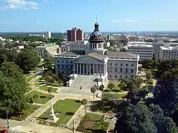
Downtown Columbia is the downtown area of Columbia, South Carolina, United States. It contains the city's central business district and the State House. It also encompasses the University of South Carolina. Columbia is the capital of South Carolina. Downtown Columbia's landmarks include the State House, Congaree River, and Capitol Center.[2]

Downtown Columbia is centered around the State House
See also
References
- ↑ "Geographic Names Information System". edits.nationalmap.gov. Retrieved 2023-05-08.
- ↑ "Columbia: Then & Now | Modern Cities". www.moderncities.com. Retrieved 2023-10-24.
This article is issued from Wikipedia. The text is licensed under Creative Commons - Attribution - Sharealike. Additional terms may apply for the media files.